 Filter: Categories of Wisconsin Historical Images
Filter: FULL_DATE of 1896
Filter: Community of Ashland
Filter: Categories of Wisconsin Historical Images
Filter: FULL_DATE of 1896
Filter: Community of Ashland
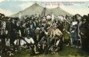
| Date: | 1896 |
|---|---|
| Description: | Colored postcard view of "Buffalo Bill" Cody center right in white coat and hat surrounded by Native Americans in traditional garb, military personnel and ... |

| Date: | 1896 |
|---|---|
| Description: | This 1896 map shows the township and range system, sections, cities and villages, railroads, roads, vacant land and land sold by the Wisconsin Central Rail... |

| Date: | 1896 |
|---|---|
| Description: | This 1898 map shows the township and range system, sections, cities and villages, railroads, roads, vacant land and land sold by the Wisconsin Central Rail... |
If you didn't find the material you searched for, our Library Reference Staff can help.
Call our reference desk at 608-264-6535 or email us at: