 Filter: Categories of Wisconsin Historical Images
Filter: FULL_DATE of 1891
Filter: Categories of Wisconsin Historical Images
Filter: FULL_DATE of 1891

| Date: | 1891 |
|---|---|
| Description: | This map shows railroads, electric street railways, block numbers, docks, roads, parks, light houses, selected buildings, and sites for manufacturers. The ... |

| Date: | 1891 |
|---|---|
| Description: | This colorful map shows additions, railroads, docks, streets, established dock lines, marshes, and proposed belt line railroad. The map covers west and sou... |

| Date: | 1891 |
|---|---|
| Description: | Large group of people posed in, on and around the frame of a barn at a barn raising. A smaller building is in the background on the left. Cultivated fields... |
| Date: | 1891 |
|---|---|
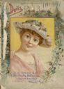
| Description: | Catalog cover with an illustration of a framed portrait of a red headed woman wearing an off-white hat and pink dress, surrounded by foliage and flowers. |
| Date: | 1891 |
|---|---|
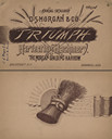
| Description: | Front and back covers of a catalog for Triumph harvesting machinery and the Morgan Spading Harrow. Features on the front are illustrations of stalks of whe... |
| Date: | 1891 |
|---|---|
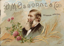
| Description: | Front cover of catalog for mowers, reapers and self-binding harvesting machinery. Features a color illustration of a portrait of a man with a beard wearing... |
| Date: | 1891 |
|---|---|
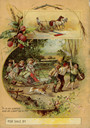
| Description: | Back cover of catalog featuring a color illustration of children riding on a harvesting machine pulled by three boys. The caption reads: "It is as simple a... |

| Date: | 1891 |
|---|---|
| Description: | Two women are sitting in chairs on the lawn in front of a house. They are wearing dark dresses. |

| Date: | 1891 |
|---|---|
| Description: | This hand-colored map shows platted additions and subdivisions, ward boundaries, schools, churches, railroads, cemeteries, parks, businesses, factories, an... |
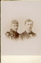
| Date: | 1891 |
|---|---|
| Description: | Dr. Otto L. and Emma Sibylla Seipp Schmidt pose for a vignetted head and shoulders portrait around the time of their marriage. Otto wears a suit and tie. E... |

| Date: | 1891 |
|---|---|
| Description: | This map shows railroads, street railways, roads, wards, block numbers, parks, and one mile concentric circles indicating distance from Post Office. Also i... |

| Date: | 1891 |
|---|---|
| Description: | This map shows vacant Southwick & Sellers lands, settlers' houses, Goodland Co. land, schools, churches, saw mills, roads, and railroads. A key in the uppe... |
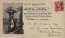
| Date: | 1891 |
|---|---|
| Description: | H.H. Bennett advertising envelope addressed to William H. Metcalf of Milwaukee. The envelope bears an engraved image of people standing on top of Stand Roc... |

| Date: | 1891 |
|---|---|
| Description: | Elevated view of First and Main Streets. A banner promoting the 1891 Wisconsin State Fair is posted on the side of a building. |
| Date: | 1891 |
|---|---|
| Description: | Frederick Layton standing on deck smoking a cigar while at sea in a Kodak #2 camera portrait by T.W. Ingersoll from St. Paul, Minnesota. The photographer's... |

| Date: | 1891 |
|---|---|
| Description: | This blueprint manuscript map shows land owned by Green Bay & Mississippi Canal Co., Meade, Vilas, Patten, and Hewitt. Streets and the Fox River are labele... |

| Date: | 1891 |
|---|---|
| Description: | This blueprint manuscript map shows land owned by Kaukauna Water Power Co., Green Bay & Mississippi Canal Co., A.W. Patten, N.M. Edwards, and M.J. Meade. P... |

| Date: | 1891 |
|---|---|
| Description: | This map shows soft marshland, water channels, solid ground, club boundary and shooting boxes. Big Lake, First Channel, Second Channel, Fout Mile Pond, Mal... |

| Date: | 1891 |
|---|---|
| Description: | This map shows soft marshland, water channels, solid ground, club boundary and shooting boxes. Big Lake, First Channel, Second Channel, Fout Mile Pond, Mal... |

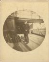
| Date: | 1891 |
|---|---|
| Description: | View across water towards the steamboat "Satirio," owned by Henry Ainsworth. There is an American flag flying from the prow, and a banner hanging off the e... |
If you didn't find the material you searched for, our Library Reference Staff can help.
Call our reference desk at 608-264-6535 or email us at: