 Filter: Categories of Wisconsin Historical Images
Filter: FULL_DATE of 1889
Filter: County of Douglas
Filter: Categories of Wisconsin Historical Images
Filter: FULL_DATE of 1889
Filter: County of Douglas
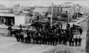
| Date: | 1889 |
|---|---|
| Description: | View of Superior, with a large group of men posting in a road in the foreground, and various buildings behind them. |

| Date: | 1889 |
|---|---|
| Description: | This 1889 map of Douglas County, Wisconsin, shows the township and range grid, towns, sections, cities and villages, roads, existing and proposed railroads... |

| Date: | 1889 |
|---|---|
| Description: | This map shows lot and block numbers, established dock lines, docks, slips, railroads, and streets of West Superior in 1889. |
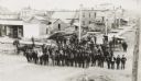
| Date: | 1889 |
|---|---|
| Description: | Elevated view of group gathered and posed on a new street. Behind the group is a large pile of lumber, wooden sidewalks, and what appear to be newly-constr... |
If you didn't find the material you searched for, our Library Reference Staff can help.
Call our reference desk at 608-264-6535 or email us at: