Filter: Categories of Wisconsin Historical Images
Filter: FULL_DATE of 1886
Filter: Categories of Wisconsin Historical Images
Filter: FULL_DATE of 1886

| Date: | 1886 |
|---|---|
| Description: | Half-length portrait of actress and singer Lillian Russell with her young daughter Dorothy Lillian Solomon, who later performed under the name Dorothy Russ... |
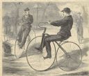
| Date: | 1886 |
|---|---|
| Description: | Engraved image from a sketch by Theodore Davis showing four men bicycling. |
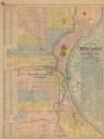
| Date: | 1886 |
|---|---|
| Description: | The map reads: "Compiled under the direction of the J.V. DUPRE ABSTRACT CO. from Dupre’s 1/4 Sectn’l Atlas of Milwaukee, by G. Steinhagen, C.E." The map co... |
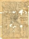
| Date: | 1886 |
|---|---|
| Description: | Two maps on one page. The first page is a map of Milwaukee County with insets "Plan of Pewaukee, Waukesha Co.," "Plan of Oconomowoc, Waukesha Co.," "Plan o... |

| Date: | 1886 |
|---|---|
| Description: | Map shows townships, post offices, roads, railroads, and selected buildings. The sections are in pink, green, blue, and yellow. Counties, towns, and lakes ... |
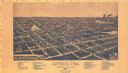
| Date: | 1886 |
|---|---|
| Description: | Bird’s-eye-view map. Map includes illustrations and index to points of interest. |
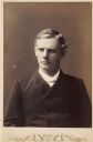
| Date: | 1886 |
|---|---|
| Description: | Quarter-length studio portrait of an unidentified man. |

| Date: | 1886 |
|---|---|
| Description: | Posed group portrait of men and women members of the “Class of '86” at Lawrence College. The 8 men have silk top hats and the 4 women have umbrellas, for a... |

| Date: | 1886 |
|---|---|
| Description: | This map has relief shown by hachures and includes a list of plats in order of date of record, laws which vacate plats, plats not shown as upon the county ... |
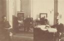
| Date: | 1886 |
|---|---|
| Description: | Philip L. Spooner, Wisconsin State Insurance Commissioner, in his office with associates. |
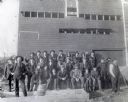
| Date: | 1886 |
|---|---|
| Description: | Outdoor group portrait of a crowd visiting Greenwood Brewery. Individuals pictured include: First row, left to right: Anton Novy, Edward McDonough, Frank R... |
| Date: | 1886 |
|---|---|
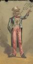
| Description: | Front of advertising card with an Uncle Sam figure with a text balloon that reads: "Read what people say of the Little Yankee Three Wheel Plow." The back o... |
| Date: | 1886 |
|---|---|
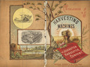
| Description: | Front and back cover of a catalog for harvesting machines. The cover features a color illustration of shocks of hay in a field surrounded by sun rays in th... |

| Date: | 1886 |
|---|---|
| Description: | Panoramic drawing of Madison, looking from the University toward the Wisconsin State Capitol. Among the locations identified along the border of the image ... |
| Date: | 1886 |
|---|---|
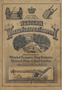
| Description: | Front cover featuring illustrations of wheeled scrapers, drag scrapers, railroad plows and road graders. |
| Date: | 1886 |
|---|---|
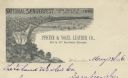
| Description: | Letterhead for the Pfister & Vogel Leather Co., with an engraving of a bird's-eye view of the city (signed Ma-- Richards, Mil Wis) advertising the "Nationa... |

| Date: | 1886 |
|---|---|
| Description: | This map shows lot and block numbers, sold lots, established dock lines, docks, slips, railroads, industrial buildings, streets, and the St. Louis Bay. |
| Date: | 1886 |
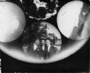
|---|---|
| Description: | An image of three men taken with a Stirn Concealed Vest Pocket Camera. The #1 Detective Camera held a 14cm round glass plate for making six 4cm wide round ... |

| Date: | 1886 |
|---|---|
| Description: | This map shows north and south ore veins, landownership, railroads, rivers, and township grid in parts of Ashland County, Wis. and Ontonagon County, Mich. ... |
If you didn't find the material you searched for, our Library Reference Staff can help.
Call our reference desk at 608-264-6535 or email us at: