Filter: Categories of Wisconsin Historical Images
Filter: FULL_DATE of 1879
Filter: Subject of human settlements
Filter: Categories of Wisconsin Historical Images
Filter: FULL_DATE of 1879
Filter: Subject of human settlements
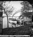
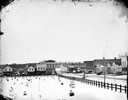
| Date: | 1879 |
|---|---|
| Description: | Norwegian Sunday School Picnic at Mendota steamboat landing. Small lake steamer "Mendota" could reach speeds of up to 18 mph. The barge "Uncle Sam" was 75f... |
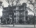
| Date: | 1879 |
|---|---|
| Description: | The facade of the McCormick family residence at 675 Rush Street, which takes up an entire block between Erie and Huron Streets. Cyrus Hall McCormick, Sr. h... |

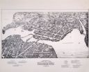
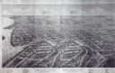
| Date: | 1879 |
|---|---|
| Description: | Bird's-eye view of Wisconsin State University, now the University of Wisconsin-Madison. Vignettes include Ladies Hall, South Dormitory, University Hall, As... |

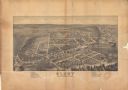
| Date: | 1879 |
|---|---|
| Description: | Bird's-eye map of Hartford. |

| Date: | 1879 |
|---|---|
| Description: | Bird's-eye map of Lake Mills. |

| Date: | 1879 |
|---|---|
| Description: | Bird's-eye map of Two Rivers. |

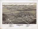
| Date: | 1879 |
|---|---|
| Description: | Bird's-eye view of Viroqua, county seat of Vernon County. |

| Date: | 1879 |
|---|---|
| Description: | This map is a bird's-eye view of Wausau, the County Seat of Marathon County. The map features an index of points of interest. |
| Date: | 1879 |
|---|---|
| Description: | Bird's-eye map of Beaver Dam. |
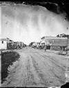
| Date: | 1879 |
|---|---|
| Description: | View of a main street looking towards The Fulton Meat Market, P. Carrington Harness shop, a livery stable, feed store, restaurant and bakery. |
| Date: | 1879 |
|---|---|
| Description: | View of main street in Lake Mills. On the left of the image are the Fargo and Ostrander store, Farmer's Cash Store and Drugs, and A.J. Foster Harness Shop.... |

| Date: | 1879 |
|---|---|
| Description: | The Reliance Flooring Mill. Men are posing in front, and another man is on a horse-drawn vehicle near the loading dock. The mill building was physically mo... |
If you didn't find the material you searched for, our Library Reference Staff can help.
Call our reference desk at 608-264-6535 or email us at: