Filter: Categories of Wisconsin Historical Images
Filter: FULL_DATE of 1878
Filter: Creator Name of Snyder Van Vechten & Co.
Filter: Categories of Wisconsin Historical Images
Filter: FULL_DATE of 1878
Filter: Creator Name of Snyder Van Vechten & Co.
| Date: | 1878 |
|---|---|
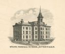
| Description: | Wisconsin State College. Caption reads: "State Normal School, River Falls." |
| Date: | 1878 |
|---|---|
| Description: | Engraving of Ocatagon House, the residence of Mrs. Eliza Richards. Several trees dot the landscape and other buildings can be seen in the distance at right... |

| Date: | 1878 |
|---|---|
| Description: | Illustrated map of Crawford County. On the bottom right is an inset of a group of people near a train on a railroad track. |
| Date: | 1878 |
|---|---|
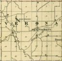
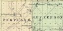
| Description: | A map of Portland and Jefferson in Monroe County. |
| Date: | 1878 |
|---|---|
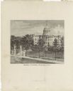
| Description: | This frontispiece lithograph shows the State Capitol with an American flag on flying on top of the dome. The grounds include trees and paths and are enclos... |

| Date: | 1878 |
|---|---|
| Description: | This lithograph shows Greenland, North America, Central America, South America, Polynesia, Australia, the Pacific Ocean, the Atlantic Ocean, the Arctic Oce... |

| Date: | 1878 |
|---|---|
| Description: | This lithograph shows Africa, Europe, Asia, Australia, and the Antarctic Continent, the Atlantic Ocean, the Indian Ocean, the Arctic Ocean, the Pacific Oce... |

| Date: | 1878 |
|---|---|
| Description: | This map shows 13 districts throughout the state. Congressional districts are outlined in red and judicial districts are outlined in blue as show borders a... |

| Date: | 1878 |
|---|---|
| Description: | This lithograph shows two agricultural scenes. The top scene shows a a farm house, barn, outbuildings, and windmill. The buildings are surround by crops an... |

| Date: | 1878 |
|---|---|
| Description: | This map shows geographic regions of the entire state. The bottom left corner includes an "Explanation of Color": Laurentien Granite (pink), Huronian Iron-... |
| Date: | 1878 |
|---|---|
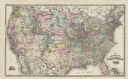
| Description: | This map shows railroad lines, states, cities, rivers, and a small portion of Canada and Mexico. States appear in pink, yellow, and green. The Gulf of Mexi... |
| Date: | 1878 |
|---|---|
| Description: | This map shows climate information for an entire year with an explanation key in the lower left corner of colors: Mean Temperature for the Year (red), Mean... |
| Date: | 1878 |
|---|---|
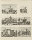
| Description: | Six lithographs are grouped together showing mostly state normal schools. The scenes clockwise from top left are: State Normal School, Oshkosh; State Norma... |

| Date: | 1878 |
|---|---|
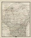
| Description: | This map shows ward boundaries in red, as well as counties, communities, rivers, lakes, Lake Michigan, and Lake Superior. The bottom left corner includes a... |
| Date: | 1878 |
|---|---|
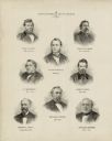
| Description: | This print shows eight former Governors of Wisconsin. In date order: "Louis P. Harvey, 1862 til April 20"; "Edward Salomon, April 20 1862-1864"; "James T. ... |
| Date: | 1878 |
|---|---|
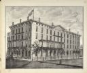
| Description: | View of Vilas House. The name on the building is Levi B. Vilas. |
| Date: | 1878 |
|---|---|
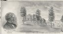
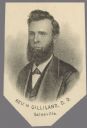
| Description: | Lithograph portrait of Reverend Harrison Gilliland, around the end of his tenure as President of Galesville University. |
If you didn't find the material you searched for, our Library Reference Staff can help.
Call our reference desk at 608-264-6535 or email us at: