 Filter: Categories of Wisconsin Historical Images
Filter: FULL_DATE of 1878
Filter: Creator Name of J. Knauber & Co.
Filter: Categories of Wisconsin Historical Images
Filter: FULL_DATE of 1878
Filter: Creator Name of J. Knauber & Co.
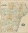
| Date: | 1878 |
|---|---|
| Description: | Outline map of Manitowoc County. Includes engraving of Wisconsin State Seal at bottom right. |
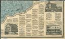
| Date: | 1878 |
|---|---|
| Description: | The bottom right corner of a map of Crawford County. This portion of the map includes town directories and illustrations of the Court House in Prairie Du C... |
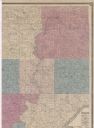
| Date: | 1878 |
|---|---|
| Description: | Portion of a map of Crawford County. |
If you didn't find the material you searched for, our Library Reference Staff can help.
Call our reference desk at 608-264-6535 or email us at: