 Filter: Categories of Wisconsin Historical Images
Filter: FULL_DATE of 1875
Filter: Creator Name of Phoenix Map Co., Milwaukee, Wisconsin
Filter: Categories of Wisconsin Historical Images
Filter: FULL_DATE of 1875
Filter: Creator Name of Phoenix Map Co., Milwaukee, Wisconsin

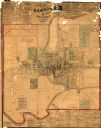
| Date: | 1875 |
|---|---|
| Description: | Shows land ownership by name, local streets, buildings, cemeteries, Chippewa River, and Half Moon Lake. Includes 1 inset map of Eau Claire. Also includes c... |

| Date: | 1875 |
|---|---|
| Description: | This map shows land ownership by name, plat of town, local streets, fairgrounds, part of White and Fox Rivers. The map includes illustrations of buildings ... |
| Date: | 1875 |
|---|---|
| Description: | This map shows plat of the town, land ownership by name, wards, local streets, railroads, and part of Fox River. The map also includes a directory and adve... |

| Date: | 1875 |
|---|---|
| Description: | This plat map shows local streets, buildings, numbered blocks and lots, part of the Red Cedar River, and land ownership by name. Also included is a busines... |
If you didn't find the material you searched for, our Library Reference Staff can help.
Call our reference desk at 608-264-6535 or email us at: