Filter: Categories of Wisconsin Historical Images
Filter: FULL_DATE of 1871
Filter: Subject of human settlements
Filter: Categories of Wisconsin Historical Images
Filter: FULL_DATE of 1871
Filter: Subject of human settlements
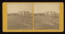
| Date: | 1871 |
|---|---|
| Description: | Ruins of building showing smokestack still standing after the Peshtigo fire. A group of men are standing on the left. |
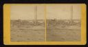
| Date: | 1871 |
|---|---|
| Description: | Street scene showing destruction after Peshtigo fire. |
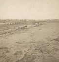
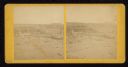
| Date: | 1871 |
|---|---|
| Description: | Fire destruction near railroad tracks after Peshtigo fire. There are wheel carriages from destroyed boxcars on and near the tracks. |
| Date: | 1871 |
|---|---|
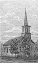
| Description: | Wood engraving of the Congregationalist Church in Peshtigo. From the book "Sketch Of The Great Fires In Wisconsin". |
| Date: | 1871 |
|---|---|
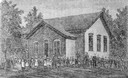
| Description: | Photographic print of a wood engraving of a schoolhouse and children in Peshtigo. From the book "Sketch of the Great Fire In Peshtigo." |

| Date: | 1871 |
|---|---|
| Description: | Drawing of the Peshtigo Fire, showing people seeking refuge in the Peshtigo River. |

| Date: | 1871 |
|---|---|
| Description: | Bird's-eye view of the Chicago fire of October 8, 1871. The hand-colored lithograph was published by Currier and Ives. |
| Date: | 1871 |
|---|---|
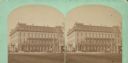
| Description: | Exterior view of the Park Hotel. Among its fine features are black walnut trim, Brussels carpet, marble-topped furniture, and spring beds. The hotel was on... |

| Date: | 1871 |
|---|---|
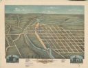
| Description: | Birds eye map of Brodhead, WI depicts street names and street locations, houses, and trees. A reference key at the bottom of the map shows the locations of... |
| Date: | 1871 |
|---|---|
| Description: | Darlington, county seat of Lafayette County, was established in the late 1840s, but didn't thrive until the arrival of the railroad in 1856. This view show... |

| Date: | 1871 |
|---|---|
| Description: | Birds eye map of Monroe, WI, depicts street names and street locations, houses, and trees. A reference key at the bottom of the map shows the locations of ... |

| Date: | 1871 |
|---|---|
| Description: | Birds eye map of New London depicts street names and street locations, houses, trees, the bridge, Wolf River, and the bayou. At the bottom of the map, a re... |

| Date: | 1871 |
|---|---|
| Description: | Like many southeastern Wisconsin villages, Edgerton was settled by Yankee immigrants in the 1830s. Though this view gives no indication of it, by 1871 toba... |
If you didn't find the material you searched for, our Library Reference Staff can help.
Call our reference desk at 608-264-6535 or email us at: