 Filter: Categories of Wisconsin Historical Images
Filter: FULL_DATE of 1868
Filter: Categories of Wisconsin Historical Images
Filter: FULL_DATE of 1868

| Date: | 1868 |
|---|---|
| Description: | Map showing the northern water routes between Mississippi River and Atlantic Ocean Relief shown by hachures. Includes Profile of the Erie Canal, table of ... |
| Date: | 1868 |
|---|---|
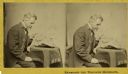
| Description: | Stereograph of Increase Lapham examining a fragment of a meteorite. |

| Date: | 1868 |
|---|---|
| Description: | This map shows land ownership by name, lots, roads, railroads, and part of the Fox River. The map includes an explanation and table of witnesses to the cor... |

| Date: | 1868 |
|---|---|
| Description: | This map is ink on tracing cloth and shows lot and block numbers, depot, railroads and side tracks, and streets in sections 24 and 25, T.11, R.16E. The map... |
| Date: | 1868 |
|---|---|
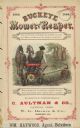
| Description: | Features an illustration of a man using a mower with a team of two horses. Caption below reads: "Here a stump is to be passed, as you now discover, And a l... |

| Date: | 1868 |
|---|---|
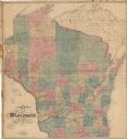
| Description: | This map of the state of Wisconsin was created in 1868 and later used by Increase Lapham to trace an outbreak of tornadoes going across the state in May of... |

| Date: | 1868 |
|---|---|
| Description: | This map shows lot and block numbers, some property ownership, wards, roads, and railroads. An inset map shows the Glidden & Lockwood’s addition. There are... |

| Date: | 1868 |
|---|---|
| Description: | This map is one of the earliest weather maps of the United States, which traced an 1859 storm across the continent. Manuscript annotations in red ink show ... |
| Date: | 1868 |
|---|---|
| Description: | This map shows railroads, counties and towns and includes a township grid. Sections are shown in blue, green, yellow, and pink. Rivers and lakes are labele... |

| Date: | 1868 |
|---|---|
| Description: | This map shows the configurations of the counties, communities, railroads and projected railroads, mines, shipping routes, and labeled rivers and lakes. Po... |

| Date: | 1868 |
|---|---|
| Description: | This map includes a table of estimated costs "by Brev. Maj. Gen. G.K. Warren Maj. U.S.E., of improvement of Wis. River from his survey of 1867." Included a... |

| Date: | 1868 |
|---|---|
| Description: | Quarter plate ferrotype/tintype of Ceylon Childs Lincoln. Full-length seated pose facing 45 degrees to the right, with left arm on cloth covered table and ... |
| Date: | 1868 |
|---|---|
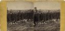
| Description: | Stereograph of an elevated view of hop harvesters, men, women and children, posing in a field at H.H. Potter's Hop Yard. Trellises of mature hops plants ar... |
| Date: | 1868 |
|---|---|
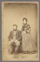
| Description: | Carte-de-visite portrait of a man and a woman. Joseph Ager, a farmer from Ripon, is sitting. His wife is standing next to him with her hand on his shoulder... |
| Date: | 1868 |
|---|---|
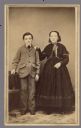
| Description: | Full-length carte-de-visite portrait of a boy and a girl standing together. The girl has her hand on the boy's shoulder. These are the children of Joseph a... |

| Date: | 1868 |
|---|---|
| Description: | Carte-de-visite of Carl Ferdinand Allen, a Danish historian and professor. He was the author of De Tre Nordiske Rigers Historie, 1497-1536, Haand... |

| Date: | 1868 |
|---|---|
| Description: | Oval-framed portrait of two children, identified as Willie Gowdy (left) and Edward Alsworth Ross (right). Willie Gowdy was Edward's half-brother. |

| Date: | 1868 |
|---|---|
| Description: | Engraved lithograph of a waist-up portrait of Brevet Brigadier General Thomas Scott Allen. Allen was a Republican member of the Wisconsin State Assembly f... |
If you didn't find the material you searched for, our Library Reference Staff can help.
Call our reference desk at 608-264-6535 or email us at: