 Filter: Categories of Wisconsin Historical Images
Filter: FULL_DATE of 1866
Filter: Type of Map or Atlas
Filter: Categories of Wisconsin Historical Images
Filter: FULL_DATE of 1866
Filter: Type of Map or Atlas

| Date: | 1866 |
|---|---|
| Description: | This detailed map shows the positions of the armies of the Ohio and Tennessee, Confederate lines, headquarters, "regimental camps at the date of the battle... |

| Date: | 1866 |
|---|---|
| Description: | This thematic shows the effects that Lake Michigan has had on Wisconsin mean temperatures in January and July. The map shows counties, some cities, rivers ... |

| Date: | 1866 |
|---|---|
| Description: | A pen on paper, hand-drawn and colored map of Wisconsin and Michigan, showing counties, cities and villages, rivers and lakes, as well as railroads are in ... |

| Date: | 1866 |
|---|---|
| Description: | A pen on paper, hand-drawn and colored map of Wisconsin and Michigan, showing counties, cities and villages, rivers and lakes, as well as railroads are in ... |

| Date: | 1866 |
|---|---|
| Description: | This map shows the railroads both completed and under construction in southern Wisconsin, Iowa, Illinois, and Missouri. Railroad terminals, junctions, and ... |

| Date: | 1866 |
|---|---|
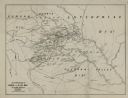
| Description: | A map of Lafayette County, Wisconsin, showing the townships and ranges, sections, towns, villages, stream and rivers, mounds, mineral deposits and the Mine... |

| Date: | 1866 |
|---|---|
| Description: | This manuscript map by Increase Lapham shows the Dells of the Wisconsin River, from Stand Rock and Witches Gulch at the north to a point approximately one ... |

| Date: | 1866 |
|---|---|
| Description: | This map shows the location of county boundaries, cities, rivers, lakes, grant railroads, wagon roads, land office locations, iron, copper and lead deposit... |
| Date: | 1866 |
|---|---|
| Description: | An accompaniment to a Gilpin County, Colorado map created by Morse and George Hill. |

| Date: | 1866 |
|---|---|
| Description: | A colorful map of Gilpin County, the central gold region of Colorado, surveyed by Charles W. Morse and George Hill. |

| Date: | 1866 |
|---|---|
| Description: | Diagram and seating chart for the Wisconsin State Senate in the second State Capitol Building which burned down in 1904. |

| Date: | 1866 |
|---|---|
| Description: | Diagram and seating chart for the Wisconsin State Assembly in the second State Capitol Building which burned down in 1904.. |
If you didn't find the material you searched for, our Library Reference Staff can help.
Call our reference desk at 608-264-6535 or email us at: