 Filter: Categories of Wisconsin Historical Images
Filter: FULL_DATE of 1859
Filter: Categories of Wisconsin Historical Images
Filter: FULL_DATE of 1859

| Date: | 1859 |
|---|---|
| Description: | Shows townships and sections, landownership, roads, railroads, rural residences, schools, churches, and topography. Relief shown by hachures. "From governm... |
| Date: | 1859 |
|---|---|
| Description: | Shows acreages and swamps in a portion of Gordon township, Ashland County, Wis. Originally published as two maps. Township lines surveyed by A.C. Stuntz ; ... |

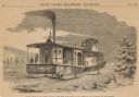
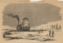
| Date: | 1859 |
|---|---|
| Description: | Steam-powered car designed to run on ice across the Mississippi River at Prairie du Chien. The LADY FRANKLIN made one successful trip across, but wa... |

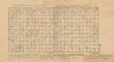
| Date: | 1859 |
|---|---|
| Description: | This map show plats including plat names, plat numbers, and some lot owner's names. Relief is shown by hachures. The map includes line drawings of Juneau B... |
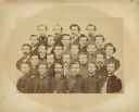
| Date: | 1859 |
|---|---|
| Description: | Typed text on back of photograph: "River Falls Rifle company, River Falls, Wis. Organized 1859, later fought with 12th Wisconsin Volunteer Regiment in Civi... |

| Date: | 1859 |
|---|---|
| Description: | This plat map is pen on paper and shows numbered blocks and lots, local streets, and section lines. Also included is text on survey certifications. |

| Date: | 1859 |
|---|---|
| Description: | This plat map is pen on paper and shows numbered blocks and lots, local streets, and section lines. Also included is text on survey certifications. The top... |
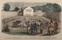
| Date: | 1859 |
|---|---|
| Description: | Hand-colored engraving showing fur company agents making a distribution of goods to Indians, some of whom are seated on the ground, in a fenced courtyard w... |

| Date: | 1859 |
|---|---|
| Description: | This hand-colored map shows township and range in pink, blue, yellow, and orange, land ownership, includes 16 city inset maps showing land ownership, and 5... |
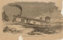
| Date: | 1859 |
|---|---|
| Description: | Engraved drawing of Norman Wiard's ice locomotive, the Lady Franklin operating on a frozen river. Male passengers and crew members are standing on t... |
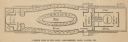
| Date: | 1859 |
|---|---|
| Description: | Floorplan of Norman Wiard's ice locomotive, the Lady Franklin showing the locations of seating, water closets, ladies' salon, boiler, engine room, e... |
| Date: | 1859 |
|---|---|
| Description: | Engraved drawing of Norman Wiard's ice locomotive, Lady Franklin being pulled from water onto ice using its anchor. The vessel was built, but never ... |
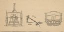
| Date: | 1859 |
|---|---|
| Description: | Cutaway details of Norman Wiard's ice locomotive, Lady Franklin sowing the stern and seating area. Also included is a drawing of the vehicle's ancho... |
| Date: | 1859 |
|---|---|
| Description: | Engraved drawing of Norman Wiard's ice locomotive, Lady Franklin leaving a snowy riverbank and entering the frozen river. The vessel was built, but ... |
If you didn't find the material you searched for, our Library Reference Staff can help.
Call our reference desk at 608-264-6535 or email us at: