 Filter: Categories of Wisconsin Historical Images
Filter: FULL_DATE of 1857
Filter: Subject of transportation
Filter: Categories of Wisconsin Historical Images
Filter: FULL_DATE of 1857
Filter: Subject of transportation
| Date: | 1857 |
|---|---|
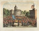
| Description: | A lithographic portrait by Louis Kurz (1833-1921) of Madison Fire Engine Company #2 posed with a hand pumper and hose cart in front of the design of the ne... |

| Date: | 1857 |
|---|---|
| Description: | Elevated view of Waukesha with two women wearing dresses with a boy in long pants and tam o'shanter hat in foreground against a split-rail fence. Beyond th... |

| Date: | 1857 |
|---|---|
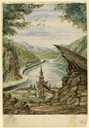
| Description: | From Judge Smith Addition, 5th Ward, looking north, toward the city. Drawing is an elevated view of field and plank fence in foreground, road to the left a... |

| Date: | 1857 |
|---|---|
| Description: | Bird's-eye view of Madison over rooftop and across lake with sailboats and steamers. A group of people are standing on a viewing platform on the roof in th... |
| Date: | 1857 |
|---|---|
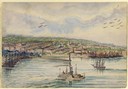
| Description: | A distant, elevated view of the city of Milwaukee and its shoreline. During the hot summer months, Hölzlhuber, took excursions on the water, many times bri... |
| Date: | 1857 |
|---|---|
| Description: | Business with Frank Leslie's Illustrated Newspaper took Hölzlhuber to New York, and from there he also visited Philadelphia, Baltimore, and Washingt... |
| Date: | 1857 |
|---|---|
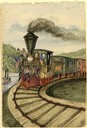
| Description: | At the opening of the railway between Grandhaven and Grand Rapids, Michigan on July 26, 1857, the locomotive Grand Rapids was manned by the railroad... |

| Date: | 1857 |
|---|---|
| Description: | Illustration of an early design for the 3rd Wisconsin State Capitol, the second in Madison. Caption reads: "State Capitol at Madison — Donnel & Kutzbock, A... |

| Date: | 1857 |
|---|---|
| Description: | A quarter section of a map of the City of Fond du Lac featuring the Empire Branch Plank Road. |

| Date: | 1857 |
|---|---|
| Description: | Quarter section of a map of the city of Fond du Lac featuring the Waupun Plank Road. |
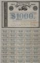
| Date: | 1857 |
|---|---|
| Description: | One thousand dollar bond and unclipped coupons issued by the city of Madison in 1857. The bond was illustrated with a railroad train, perhaps to suggest th... |
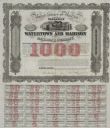
| Date: | 1857 |
|---|---|
| Description: | One thousand dollar bond and coupons issued by the Watertown and Madison Railroad Company in 1857. Jairus Fairchild, president, and T.L. Lawrence have sig... |
| Date: | 1857 |
|---|---|
| Description: | Draft newspaper editorial, "Our Railroad Prospects," written by former governor Leonard J. Farwell. |

| Date: | 1857 |
|---|---|
| Description: | Information depicting the history, condition and prospects of the Indian tribes of the United States: collected and prepared under the direction of the Bur... |
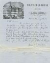
| Date: | 1857 |
|---|---|
| Description: | Letter on stationery featuring an engraving of an exterior view of the Milwaukee House showing horse-drawn vehicles and people standing on the sidewalk in ... |
| Date: | 1857 |
|---|---|
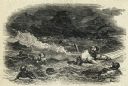
| Description: | Illustration from Frank Leslie's Illustrated Newspaper of John Tice clinging to a piece of wreckage after the sinking of the steamer Central Amer... |
| Date: | 1857 |
|---|---|
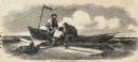
| Description: | John Tice and Alexander Grant helping George W. Dawson from a floating piece of debris into a lifeboat after the sinking of the steamer Central America<... |
| Date: | 1857 |
|---|---|
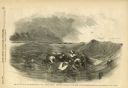
| Description: | George W. Dawson, an African-American passenger from the steamer Central America swims to a piece of debris to which several men are clinging after ... |

| Date: | 1857 |
|---|---|
| Description: | This map of Sheboygan Harbor shows the river mouth and harbor, piers, wharfs, piles of old destroyed bridge wharfs, streets, and the lake shore from survey... |

| Date: | 1857 |
|---|---|
| Description: | This detailed map was drawn nearly a decade after Wisconsin entered statehood. It depicts the entire state, northern Illinois and part of the upper peninsu... |
If you didn't find the material you searched for, our Library Reference Staff can help.
Call our reference desk at 608-264-6535 or email us at: