Filter: Categories of Wisconsin Historical Images
Filter: FULL_DATE of 1856
Filter: County of Columbia
Filter: Categories of Wisconsin Historical Images
Filter: FULL_DATE of 1856
Filter: County of Columbia
| Date: | 1856 |
|---|---|
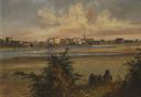
| Description: | "After painting a number of Fox River scenes, "the artists continued their way to Fond du Lac, at the south end of Lake Winnebago, where they found some mo... |

| Date: | 1856 |
|---|---|
| Description: | This map shows plat of town, local streets, railroads, projected railroads, residential buildings, mills, and part of the Crawfish River. The map includes ... |

| Date: | 1856 |
|---|---|
| Description: | This map is ink and pencil on paper and shows plat of the town, local streets, and blocks and lots by number. The map includes explanatory text. |

| Date: | 1856 |
|---|---|
| Description: | This plat shows block and lot numbers and land reserved for a railroad and passenger depot. The map includes certifications and registration. Kilbourn City... |
If you didn't find the material you searched for, our Library Reference Staff can help.
Call our reference desk at 608-264-6535 or email us at: