 Filter: Categories of Wisconsin Historical Images
Filter: FULL_DATE of 1855
Filter: Categories of Wisconsin Historical Images
Filter: FULL_DATE of 1855
| Date: | 1855 |
|---|---|
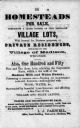
| Description: | Poster advertising homesteads and village lots for sale. |

| Date: | 1855 |
|---|---|
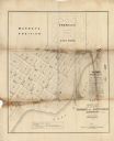
| Description: | This map shows lot and block numbers, buildings, some landownership, roads, railroads, cemeteries, the Milwaukee River, and Lake Michigan. The map includes... |

| Date: | 1855 |
|---|---|
| Description: | This map shows streets and lots. The right side of the map includes notes on widths of streets and certifications. The top right reads: "Parish's Addition ... |

| Date: | 1855 |
|---|---|
| Description: | This map shows landownership, lot and block numbers, streets, a canal, bridges, Fort Winnebago, the Wisconsin River, and the Fox River. Relief is shown by ... |
| Date: | 1855 |
|---|---|
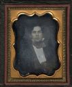
| Description: | An eighth plate daguerreotype of Edward P. Bridgman, 1834-1915, as a young man. Bridgman served in the 37th Massachusetts volunteer Infantry, Company G in ... |
| Date: | 1855 |
|---|---|
| Description: | This map shows plat of town, local streets, numbered blocks and lots, proposed city park, Murray’s addition, and part of Lake Michigan. Also includes a tab... |
| Date: | 1855 |
|---|---|
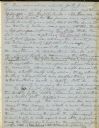
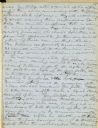
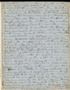
| Description: | The second page of General Henry Dodge's notes, taken by Lyman Draper. |
| Date: | 1855 |
|---|---|
| Description: | The third of four pages of General Henry Dodge's notes, as taken by Lyman Draper. |
| Date: | 1855 |
|---|---|
| Description: | The notes of General Henry Dodge, as taken by Lyman Draper. Page 99. |

| Date: | 1855 |
|---|---|
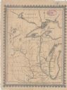
| Description: | This map shows the locations of ancient works in the state of Wisconsin. Lake Superior and Michigan are labeled. Counties, towns, and rivers are also label... |

| Date: | 1855 |
|---|---|
| Description: | This map shows current and purposed railroad routes. Lake Michigan is on the far right, with Lake Superior visible at the top of the map. Routes are marked... |
| Date: | 1855 |
|---|---|
| Description: | This map shows railroad lines from Chicago, with emphasis on the proposed railroad from Chicago to Madison to Lake Superior near the Ontonagon River. Inclu... |

| Date: | 1855 |
|---|---|
| Description: | Quarter-length oval-framed portrait of John Bascom at the age of 28. |

| Date: | 1855 |
|---|---|
| Description: | This map shows the Fox River, Lake Winnebago, streets, and plats. Below the title reads: "N. F.&Co. will make surveys of lands and plat the same in the bes... |

| Date: | 1855 |
|---|---|
| Description: | Three-quarter length sitting portrait of James Strang. |

| Date: | 1855 |
|---|---|
| Description: | Copy print of a quarter-length daguerreotype portrait of James Jesse Strang. |
| Date: | 1855 |
|---|---|
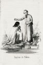
| Description: | Illustration of Father Florimond Bonduel baptizing a Menominee woman named Nakam by pouring water from a clam shell onto her head. The woman is kneeling at... |
| Date: | 1855 |
|---|---|
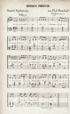
| Description: | A page of Menominee Indian music as transcribed by Father Florimond Bonduel. |
If you didn't find the material you searched for, our Library Reference Staff can help.
Call our reference desk at 608-264-6535 or email us at: