 Filter: Categories of Wisconsin Historical Images
Filter: FULL_DATE of 1855
Filter: Subject of transportation
Filter: Categories of Wisconsin Historical Images
Filter: FULL_DATE of 1855
Filter: Subject of transportation

| Date: | 1855 |
|---|---|
| Description: | Bird's-eye view of Madison. "Taken from the Water Cure, South Side of Lake Monona, 1855." |

| Date: | 1855 |
|---|---|
| Description: | Quarter plate daguerreotype of the Oshkosh harbor, showing the bridge over the Fox River and several moored sailing vessels. |
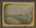
| Date: | 1855 |
|---|---|
| Description: | Half plate daguerreotype, with view across water of the Oshkosh, Wisconsin harbor showing the bridge over the Fox River. Moored on the opposite shore are t... |

| Date: | 1855 |
|---|---|
| Description: | Detail from a lithograph vignette on a Map of the City of Madison of the third Wisconsin State Capitol, the first Capitol in Madison. |

| Date: | 1855 |
|---|---|
| Description: | Part of George Harrison's "Map of the City of Madison," showing the development of the isthmus and the small size of the second Capitol (54' x 104') in com... |

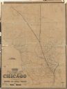
| Date: | 1855 |
|---|---|
| Description: | Map of the city of Madison, Dane County, published by George Harrison, surveyed and drawn by P. McCabe, and engraved by J.H. Colton & Co., New York. In add... |

| Date: | 1855 |
|---|---|
| Description: | Fox-Wisconsin portage and canal map, when the canal was not yet built. From a map in the office of the city clerk at Portage. "The old trail, the location ... |

| Date: | 1855 |
|---|---|
| Description: | Map reads "Our Country" which is accompanied by a sailor with a flag to the left and workers rejoicing under the Constitution and Laws to the right. Across... |
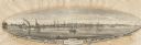
| Date: | 1855 |
|---|---|
| Description: | View of Detroit with several boats and ships in (probably) the Detroit River. |
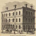
| Date: | 1855 |
|---|---|
| Description: | Clipping from a newspaper or magazine. Building on a corner with a Post Office sign on left side of building, Custom House sign on the right side. Horse-... |

| Date: | 1855 |
|---|---|
| Description: | Map of Milwaukee, Waukesha, Racine, and Kenosha Counties with part of Walworth County showing townships, waterways, railroads, plank roads, prairies, meado... |

| Date: | 1855 |
|---|---|
| Description: | Drawn around 1855, this map shows the placement of railroad tracks in southern Wisconsin and northern Illinois connecting Milwaukee, Prairie du Chien, Gale... |

| Date: | 1855 |
|---|---|
| Description: | Map of Wisconsin, showing railway routes throughout the state as well as the names of the counties, townships, and cities in the state. The inset of the ma... |

| Date: | 1855 |
|---|---|
| Description: | This map shows counties, cities, rivers, canals, lakes, railroads, common roads, county towns, townships, villages, and post offices. The map includes part... |
| Date: | 1855 |
|---|---|
| Description: | A map of Wisconsin and northern Illinois, showing the railroad routes in these areas, specifically the Fox River Valley, Wisconsin Central and the Ontonago... |

| Date: | 1855 |
|---|---|
| Description: | Drawn seven years after Wisconsin entered statehood, this map shows the counties, cities, towns, rivers and lakes in the entire state. The map includes a c... |

| Date: | 1855 |
|---|---|
| Description: | This map shows the entire state and part of the Upper Peninsula of Michigan. It depicts creeks, rivers, lakes, railroads completed, railroads in progress, ... |

| Date: | 1855 |
|---|---|
| Description: | This Wisconsin map depicts counties, creeks, rivers, lakes, railroads completed, railroads in progress, common roads and the Menomonee Reservation. |

| Date: | 1855 |
|---|---|
| Description: | This map depicts counties, creeks, rivers, lakes, railroads completed, railroads in progress, common roads and the Menomonee Reservation. |

| Date: | 1855 |
|---|---|
| Description: | This map shows the township survey grid and identifies counties, named towns, rivers, lakes, railroads, plank roads, mines, and the Menomonee Reservation. ... |
If you didn't find the material you searched for, our Library Reference Staff can help.
Call our reference desk at 608-264-6535 or email us at: