 Filter: Categories of Wisconsin Historical Images
Filter: FULL_DATE of 1855
Filter: Subject of human settlements
Filter: Categories of Wisconsin Historical Images
Filter: FULL_DATE of 1855
Filter: Subject of human settlements

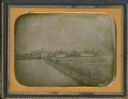
| Date: | 1855 |
|---|---|
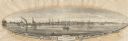
| Description: | Bird's-eye view of Madison. "Taken from the Water Cure, South Side of Lake Monona, 1855." |

| Date: | 1855 |
|---|---|
| Description: | Quarter plate daguerreotype of the Oshkosh harbor, showing the bridge over the Fox River and several moored sailing vessels. |
| Date: | 1855 |
|---|---|
| Description: | Half plate daguerreotype, with view across water of the Oshkosh, Wisconsin harbor showing the bridge over the Fox River. Moored on the opposite shore are t... |

| Date: | 1855 |
|---|---|
| Description: | Detail from a lithograph vignette on a Map of the City of Madison of the third Wisconsin State Capitol, the first Capitol in Madison. |

| Date: | 1855 |
|---|---|
| Description: | Part of George Harrison's "Map of the City of Madison," showing the development of the isthmus and the small size of the second Capitol (54' x 104') in com... |
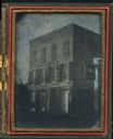
| Date: | 1855 |
|---|---|
| Description: | Quarter plate ambrotype of a brick structure, possibly in Green Bay, Wisconsin, housing the office of J.S. Baker, Land Agent. The building is three stories... |
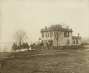
| Date: | 1855 |
|---|---|
| Description: | Early view of the house built by Madison's first mayor, Jairus C. Fairchild, at 302 South Wisconsin Avenue (renamed Monona Avenue in 1877) at West Wilson S... |
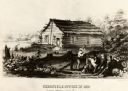
| Date: | 1855 |
|---|---|
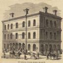
| Description: | Chronicle newspaper office, the first building on the townsite of Superior, built in 1853 by William C. Howenstine, John T. Morgan, and August Zachau. |

| Date: | 1855 |
|---|---|
| Description: | Map of the city of Madison, Dane County, published by George Harrison, surveyed and drawn by P. McCabe, and engraved by J.H. Colton & Co., New York. In add... |
| Date: | 1855 |
|---|---|
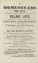
| Description: | Advertisment of Leonard J. Farwell from the 1855 Madison City Directory for the real estate property he had for sale. At the time Farwell was the largest ... |

| Date: | 1855 |
|---|---|
| Description: | Map of Madison and surrounding communities, referred to as the four lakes country. Text bordering the map includes an excerpt of a letter written by Horace... |

| Date: | 1855 |
|---|---|
| Description: | Fox-Wisconsin portage and canal map, when the canal was not yet built. From a map in the office of the city clerk at Portage. "The old trail, the location ... |

| Date: | 1855 |
|---|---|
| Description: | Map reads "Our Country" which is accompanied by a sailor with a flag to the left and workers rejoicing under the Constitution and Laws to the right. Across... |
| Date: | 1855 |
|---|---|
| Description: | View of Detroit with several boats and ships in (probably) the Detroit River. |
| Date: | 1855 |
|---|---|
| Description: | Clipping from a newspaper or magazine. Building on a corner with a Post Office sign on left side of building, Custom House sign on the right side. Horse-... |
| Date: | 1855 |
|---|---|
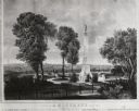
| Description: | Lithograph showing the projected plan for the memorial. Monument is on top of a hill, looking out over the city, with a fenced off park area. Seven people ... |

| Date: | 1855 |
|---|---|
| Description: | Drawn around 1855, this map shows the placement of railroad tracks in southern Wisconsin and northern Illinois connecting Milwaukee, Prairie du Chien, Gale... |

| Date: | 1855 |
|---|---|
| Description: | Map of Wisconsin, showing railway routes throughout the state as well as the names of the counties, townships, and cities in the state. The inset of the ma... |

| Date: | 1855 |
|---|---|
| Description: | Drawn three years before Minnesota entered statehood, this map shows Minnesota Territory and the western part of Wisconsin. The map shows county lines, riv... |
If you didn't find the material you searched for, our Library Reference Staff can help.
Call our reference desk at 608-264-6535 or email us at:
