 Filter: Categories of Wisconsin Historical Images
Filter: FULL_DATE of 1854
Filter: Creator Name of Unknown
Filter: Categories of Wisconsin Historical Images
Filter: FULL_DATE of 1854
Filter: Creator Name of Unknown
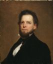
| Date: | 1854 |
|---|---|
| Description: | Quarter-length portrait of Lyman C. Draper. This shows him at the time he assumed the position of Historical Society superintendent, at the age of 38. |
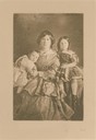
| Date: | 1854 |
|---|---|
| Description: | Jerusha Sturgis with Nina and Jack Sturgis as toddlers. |
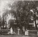
| Date: | 1854 |
|---|---|
| Description: | View of the Bridgeman house with three adults and a child posed along a fence in front of it. |
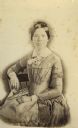
| Date: | 1854 |
|---|---|
| Description: | Sarah Goodnow married early Madison settler Darwin Clark in 1848 and died in Madison in 1854. Her sister Sophia was married to Madison pharmacist Philo Du... |
| Date: | 1854 |
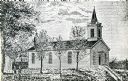
|---|---|
| Description: | Exterior view of a First Congregational Church. |
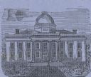
| Date: | 1854 |
|---|---|
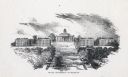
| Description: | Engraving of the first capitol building built in Madison used as an illustration by the Madison Mutual Insurance Company, a first insurance company, the di... |
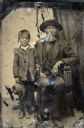
| Date: | 1854 |
|---|---|
| Description: | Tintype of Michael De Perry and unidentified child. |
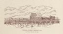
| Date: | 1854 |
|---|---|
| Description: | A horse-drawn carriage is crossing the bridge. Right of center is the S. Ball's Candy Store. |
| Date: | 1854 |
|---|---|
| Description: | View up Bascom Hill on the University of Wisconsin-Madison campus. |
| Date: | 1854 |
|---|---|
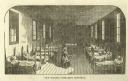
| Description: | An illustration of a nun/nurse carrying a pitcher in the sick ward of Charity Hospital. Patients lay in rows of beds along the walls. |
| Date: | 1854 |
|---|---|
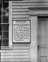
| Description: | A plaque on the exterior of the building declares the birthplace of the Republican Party. |

| Date: | 1854 |
|---|---|
| Description: | This map is ink and watercolor on tracing cloth and shows lot and block numbers, streets, a park, and depots. Some lots are colored red or blue and some in... |

| Date: | 1854 |
|---|---|
| Description: | This map shows proposed counties in northern Wisconsin included Douglas, La Pointe, Polk, Chippewa, Dunn, St. Croix, Pierce and Clark. This map shows the p... |

| Date: | 1854 |
|---|---|
| Description: | This mid-19th century map of Dane County, Wisconsin, shows the township and range grid, towns, sections, cities, villages and post offices, lakes and strea... |

| Date: | 1854 |
|---|---|
| Description: | Shows street grid, sections in adjacent townships, routes of railroads and projected railroads, post offices, and creeks. Table of references identifies ma... |

| Date: | 1854 |
|---|---|
| Description: | Sixth plate daguerreotype portrait of Charles Foster of Monroe, Wisconsin, in suit, vest, tie and stand collar. Hand-coloring on cheeks. |
| Date: | 1854 |
|---|---|
| Description: | Sixth plate daguerreotype of Rosellah Smith (Donnel) Bowman. Mrs, Bowman was married to Samuel Hunter Donnel, architect, from 1854 to 1860. Samuel and Rose... |
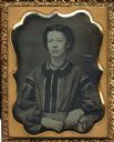
| Date: | 1854 |
|---|---|
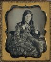
| Description: | Ninth plate daguerreotype of Laura Smith. Miss. Smith was the sister of Rosellah Bowman; she died of consumption in Athol, MA. The portrait is a half figur... |

| Date: | 1854 |
|---|---|
| Description: | This map is mounted on cloth and shows lot and block numbers, streets, additions, and public squares. Also included is information on Trempealeau, an inset... |
If you didn't find the material you searched for, our Library Reference Staff can help.
Call our reference desk at 608-264-6535 or email us at:
