 Filter: Categories of Wisconsin Historical Images
Filter: FULL_DATE of 1854
Filter: Creator Name of Gunnison, J. W. (John Williams), 1812-1853
Filter: Categories of Wisconsin Historical Images
Filter: FULL_DATE of 1854
Filter: Creator Name of Gunnison, J. W. (John Williams), 1812-1853

| Date: | 1854 |
|---|---|
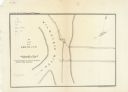
| Description: | This map shows bay and harbor soundings, the Milwaukee River, and select buildings. Depths are shown by soundings and relief is shown by hachures. The top ... |
| Date: | 1854 |
|---|---|
| Description: | This map is oriented with north slightly to the right and the Milwaukee River is labeled. The top margin reads: "Senate Ex. Doc. No. 1. 1st Session, 33rd C... |
If you didn't find the material you searched for, our Library Reference Staff can help.
Call our reference desk at 608-264-6535 or email us at: