 Filter: Categories of Wisconsin Historical Images
Filter: FULL_DATE of 1851
Filter: Categories of Wisconsin Historical Images
Filter: FULL_DATE of 1851
| Date: | 1851 |
|---|---|
| Description: | View across lawn toward the chapel at Ripon College. The bottom half of the structure is made of brick and has tall, stained-glass windows. Above this is a... |

| Date: | 1851 |
|---|---|
| Description: | View across lawn toward the chapel at Ripon College. The bottom half of the structure is made of brick and has tall, stained-glass windows. Above this is a... |

| Date: | 1851 |
|---|---|
| Description: | View looking uphill toward the back of Ingraham Hall at Ripon College. The primary material used is brick, and the foundation and basement are stone. The b... |
| Date: | 1851 |
|---|---|
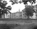
| Description: | View across lawn toward the Wright, Evans, and Shaler Halls at Ripon College. The building is made out of stone, and a porch with columns protects each doo... |

| Date: | 1851 |
|---|---|
| Description: | A pathway leads to Merriman Hall at Ripon College. The columned porch shelters a double door entrance and supports a second floor balcony. The middle thir... |
| Date: | 1851 |
|---|---|
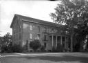
| Description: | Smith Hall at Ripon College features a three-story porch, supported by columns and which shelters the entrance. Brackets add decoration to the roof. Vines ... |

| Date: | 1851 |
|---|---|
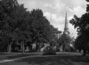
| Description: | A view of campus green space at Ripon College. A commemorative stone marker in the foreground has text that reads: "Rendezvous 1st Wis. Cav. Aug. 15 to Nov... |

| Date: | 1851 |
|---|---|
| Description: | Map exhaustively marks the townships, County Towns and villages of Wisconsin. It also shows rivers, canals, railroads, and plank roads. Each county's popul... |

| Date: | 1851 |
|---|---|
| Description: | Diagram of an effigy mound in the shape of a cross. |

| Date: | 1851 |
|---|---|
| Description: | Map of a portion of Merton including the Bark River, a mill, Fort Hill, and Indian mounds. |

| Date: | 1851 |
|---|---|
| Description: | A survey map of Wisconsin and eastern Minnesota, with the township surveys for portions of the Saint Croix region in progress. The maps also show the Meno... |

| Date: | 1851 |
|---|---|
| Description: | Map outlines mid and southern Wisconsin county boundaries in blue, and city/town lines are provided. Other marks include mines, plank roads, and railroads. |

| Date: | 1851 |
|---|---|
| Description: | This manuscript map of the southern portion of the Town of Porterfield, Marinette County, Wisconsin, shows sections and land ownership. The Menominee River... |
| Date: | 1851 |
|---|---|
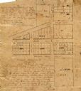
| Description: | Ink and pencil on paper. Shows plat of Delafield and local streets. Streets running left to right, top to bottom, are "Main Street 66 feet," "Wells Street ... |

| Date: | 1851 |
|---|---|
| Description: | This map shows plats with lots and block numbers of Madison. The far left corner features "University Ground" and some streets are labeled. Lake Monona is ... |

| Date: | 1851 |
|---|---|
| Description: | Illustration of two men using a Hussey Grain Cutter in a field. One man is riding on the grain cutter, and another man is riding on one of two horses pulli... |
| Date: | 1851 |
|---|---|
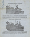
| Description: | Back side of direction sheet, featuring two illustrations of men using the machine in a field. The top illustration has the title: "This cut represents the... |
| Date: | 1851 |
|---|---|
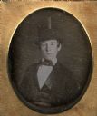
| Description: | Sixth plate daguerreotype of Charles Krips. Charles Krips was the uncle of the donor of the portrait, Mrs. Julia Hicks. The portrait is a bust figure, faci... |

| Date: | 1851 |
|---|---|
| Description: | This map shows townships, villages, Indian villages, railroads, roads, mills, prairies, swamps, and canals. An inset map shows a plat of the copper distric... |

| Date: | 1851 |
|---|---|
| Description: | This map shows labeled counties in Wisconsin and unlabeled county in Michigan. It includes Door County, which was established 1851, but lacks Kewaunee Coun... |
If you didn't find the material you searched for, our Library Reference Staff can help.
Call our reference desk at 608-264-6535 or email us at: