 Filter: Categories of Wisconsin Historical Images
Filter: FULL_DATE of 1846
Filter: Creator Name of Unknown
Filter: Categories of Wisconsin Historical Images
Filter: FULL_DATE of 1846
Filter: Creator Name of Unknown
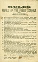
| Date: | 1846 |
|---|---|
| Description: | "Rules to be observed by the pupils of public schools of Milwaukee." |
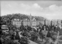
| Date: | 1846 |
|---|---|
| Description: | A view of the college and surrounding green space at Saint Clara Academy. Saint Clara Academy moved to River Forest, Illinois in 1922, and since 1970 has g... |

| Date: | 1846 |
|---|---|
| Description: | This map of Prairieville, later renamed Waukesha, is ink and pencil on paper and shows the Fox River, a plat of village, and lot owners. |

| Date: | 1846 |
|---|---|
| Description: | This map is paint and ink on board with relief shown pictorially. The map was planned by Alfred Ames, drawn by one daughter and painted by another daughter... |
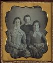
| Date: | 1846 |
|---|---|
| Description: | Sixth plate daguerreotype of Betsy H. Smith, left, with her daughter, Laura, right,and son, George. The three are the mother, sister and brother of Rosella... |

| Date: | 1846 |
|---|---|
| Description: | This plat map, which features the very early spelling of Wisconsin as "Wiskonsin", was created sometime between 1846 and 1854 and shows a canal and dam on ... |

| Date: | 1846 |
|---|---|
| Description: | Three-quarter length portrait of David Agry, member of the Wisconsin State Assembly from the Brown County district, 1848-1849. He was a lawyer, jurist, and... |
If you didn't find the material you searched for, our Library Reference Staff can help.
Call our reference desk at 608-264-6535 or email us at: