 Filter: Categories of Wisconsin Historical Images
Filter: FULL_DATE of 1839
Filter: Creator Name of Unknown
Filter: Categories of Wisconsin Historical Images
Filter: FULL_DATE of 1839
Filter: Creator Name of Unknown

| Date: | 1839 |
|---|---|
| Description: | A map of the Wiskonsin [sic] and Neenah or Fox Rivers. |
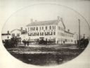
| Date: | 1839 |
|---|---|
| Description: | Exterior view of the Racine House with multiple horse-drawn wagons and figures standing in front. |

| Date: | 1839 |
|---|---|
| Description: | Map of a canal route to avoid the principal rapids of the Neenah or Fox River between Lake Winnebago and Green Bay. |
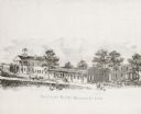
| Date: | 1839 |
|---|---|
| Description: | Courthouse and surrounding buildings. There are also two horse-drawn carriages, people on horseback, and a few pedestrians. |
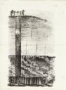
| Date: | 1839 |
|---|---|
| Description: | Cut-away lithography illustration of a mining operation, showing men lowering a miner into a mine where several other men are working. |
If you didn't find the material you searched for, our Library Reference Staff can help.
Call our reference desk at 608-264-6535 or email us at:
