 Filter: Categories of Wisconsin Historical Images
Filter: FULL_DATE of 1838
Filter: Subject of transportation
Filter: Categories of Wisconsin Historical Images
Filter: FULL_DATE of 1838
Filter: Subject of transportation
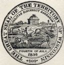
| Date: | 1838 |
|---|---|
| Description: | Territorial seal of Wisconsin. There is a farmer in the foreground plowing behind horses, a Native American apparently heading west, a river steamboat and ... |
| Date: | 1838 |
|---|---|
| Description: | This map of the Wisconsin Territory, accompanied by the photostat of an article from the January 13, 1838, Wisconsin democrat, shows the area described as ... |

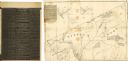
| Date: | 1838 |
|---|---|
| Description: | A map of the proposed route of the Milwaukee and Rock River Canal from Fort Atkinson on the Rock River in the west to the city of Milwaukee and Lake Michig... |
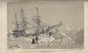
| Date: | 1838 |
|---|---|
| Description: | Position of H.M.S. Terror on the 22nd of February, 1837. The sailing ship was immobilized in the sea ice near Southampton Island, at the entrance to... |

| Date: | 1838 |
|---|---|
| Description: | Ox-drawn cart in which Mr. and Mrs. Salmon Upson traveled from Connecticut in 1838. |

| Date: | 1838 |
|---|---|
| Description: | A color map of the settled part of Wisconsin Territory in 1838, including an inset map of the "Entire Territory of Wisconsin as Established by Act of Congr... |

| Date: | 1838 |
|---|---|
| Description: | This map is a development plat that shows street names, numbered blocks and lots, and small farm lot owners. Included on the right of the map is a large am... |

| Date: | 1838 |
|---|---|
| Description: | Drawing of Shullsburg. There is a numbered key on the left that reads, at top: "Explanation. Nos. Denote present Site." Streets are named on the map and ma... |
If you didn't find the material you searched for, our Library Reference Staff can help.
Call our reference desk at 608-264-6535 or email us at: