 Filter: Categories of Wisconsin Historical Images
Filter: FULL_DATE of 1838
Filter: Subject of human settlements
Filter: Categories of Wisconsin Historical Images
Filter: FULL_DATE of 1838
Filter: Subject of human settlements
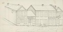
| Date: | 1838 |
|---|---|
| Description: | Pencil sketch of a building owned by the Rodolf family along a commercial street. |
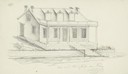
| Date: | 1838 |
|---|---|
| Description: | Pencil sketch of a stone house with a porch the full length of the dwelling, supported by 6 columns. |
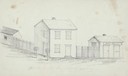
| Date: | 1838 |
|---|---|
| Description: | Pencil sketch of buildings, including the Post Office. |

| Date: | 1838 |
|---|---|
| Description: | The Odd Fellows Hall, built in 1837-1838, was the first to be built west of the Allegheny Mountains. The cornerstones were laid by Thomas Widley. |

| Date: | 1838 |
|---|---|
| Description: | Compiled from the latest authorities. Published by Hinman and Dutton. |
| Date: | 1838 |
|---|---|
| Description: | Map of the entire territories of Iowa and Wisconsin. |
| Date: | 1838 |
|---|---|
| Description: | This map of the Wisconsin Territory, accompanied by the photostat of an article from the January 13, 1838, Wisconsin democrat, shows the area described as ... |

| Date: | 1838 |
|---|---|
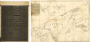
| Description: | This manuscript map, drawn in pencil, shows the lakes and rivers in the area between Lake of the Woods in northern Minnesota, the Mississippi River on the ... |

| Date: | 1838 |
|---|---|
| Description: | A map of the proposed route of the Milwaukee and Rock River Canal from Fort Atkinson on the Rock River in the west to the city of Milwaukee and Lake Michig... |

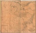
| Date: | 1838 |
|---|---|
| Description: | A color map of the settled part of Wisconsin Territory in 1838, including an inset map of the "Entire Territory of Wisconsin as Established by Act of Congr... |

| Date: | 1838 |
|---|---|
| Description: | This map is a development plat that shows street names, numbered blocks and lots, and small farm lot owners. Included on the right of the map is a large am... |
| Date: | 1838 |
|---|---|
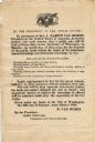
| Description: | Broadside advertising the public sale of land at Green Bay, issued by Martin Van Buren. |

| Date: | 1838 |
|---|---|
| Description: | Drawing of Shullsburg. There is a numbered key on the left that reads, at top: "Explanation. Nos. Denote present Site." Streets are named on the map and ma... |
If you didn't find the material you searched for, our Library Reference Staff can help.
Call our reference desk at 608-264-6535 or email us at: