 Filter: Categories of Wisconsin Historical Images
Filter: FULL_DATE of 1835
Filter: Categories of Wisconsin Historical Images
Filter: FULL_DATE of 1835

| Date: | 1835 |
|---|---|
| Description: | This map is pen-and-ink on paper. The map shows landowners in "Milwalky" or present day Milwaukee. Includes "list of property offered to Mr. Walker". The m... |

| Date: | 1835 |
|---|---|
| Description: | Plat map of Milwaukee. Pen-and-ink and watercolor on paper. Certifications on back side signed by several early settlers, as well as a justice of the peace... |
| Date: | 1835 |
|---|---|
| Description: | Page from Increase Lapham's 1935 botanical diary in which he listed plants he observed in flower stage. |
| Date: | 1835 |
|---|---|
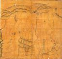
| Description: | This map covers the Western Territory of the United States from the Rocky Mountains in Colorado south to Fort Smith, Arkansas, and from the Pacific Ocean e... |

| Date: | 1835 |
|---|---|
| Description: | An illustration of three men sitting at a table in a saloon on a steamboat. |

| Date: | 1835 |
|---|---|
| Description: | Map shows the Fox River, lot and block numbers, private claims, streets, a public squares, a manual labour school, and Fort Howard. An inset map shows a pl... |
If you didn't find the material you searched for, our Library Reference Staff can help.
Call our reference desk at 608-264-6535 or email us at: