 Filter: Categories of Wisconsin Historical Images
Filter: FULL_DATE of 1834
Filter: Subject of water
Filter: Categories of Wisconsin Historical Images
Filter: FULL_DATE of 1834
Filter: Subject of water

| Date: | 1834 |
|---|---|
| Description: | Peck-a-ton-oka (Pecatonica River) with Rodolf farm in the background. |

| Date: | 1834 |
|---|---|
| Description: | This copy of an 1834 map in the American Fur Company's papers held by the New-York Historical Society shows an outline of Chequamegon Bay and Madeline Isla... |

| Date: | 1834 |
|---|---|
| Description: | This map is pen, ink, and pencil on paper and shows plat of the town, local streets, mills, forts, hospitals, and parts of Devil River and Fox River. |
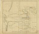
| Date: | 1834 |
|---|---|
| Description: | This map shows the locations of Indian tribes, and lands sold and ceded, as well as roads, forts, and rivers. Lands in the Great Plains are covered, and Ar... |
If you didn't find the material you searched for, our Library Reference Staff can help.
Call our reference desk at 608-264-6535 or email us at:
