 Filter: Categories of Wisconsin Historical Images
Filter: FULL_DATE of 1833
Filter: Categories of Wisconsin Historical Images
Filter: FULL_DATE of 1833
| Date: | 1833 |
|---|---|
| Description: | Mac-Cut-I-Mish-E-Ca-Cu-Cac or Black Hawk, a celebrated Sac (Sauk) Chief. Hand-colored lithograph from the Aboriginal Portfolio, drawn at Detroit (1833). |

| Date: | 1833 |
|---|---|
| Description: | Abigail Louise Smith Tallmadge (1804-1857) was the daughter of a New York judge and the mother of nine children. This portrait of Mrs. Tallmadge was painte... |

| Date: | 1833 |
|---|---|
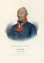
| Description: | "Tallmadge, Nathaniel Pitcher (Feb. 8, 1795-Nov. 2, 1864), lawyer, politician, U.S. Senator from N.Y., territorial governor of Wisconsin, b. Chatham, N.Y. ... |

| Date: | 1833 |
|---|---|
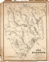
| Description: | Township/section map showing Rodolf land and nearby neighbors. |
| Date: | 1833 |
|---|---|
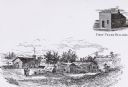
| Description: | Illustration of the Solomon Juneau fur trading post at Milwaukee in 1833. |

| Date: | 1833 |
|---|---|
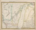
| Description: | Map of part of the military road from Fort Crawford to Fort Howard. "Recorded on pages 668.669 Book B." Surveyed by Lieut. Center. Scale: 2 miles = 1 inch. |
| Date: | 1833 |
|---|---|
| Description: | Published by Baldwin and Craddock under the superintendence of the Society for the Diffusion of Useful Knowledge, April 1, 1833. Printed by Russell Penge; ... |

| Date: | 1833 |
|---|---|
| Description: | Published in James Smith Buck's, "Pioneer History of Milwaukee". Lake Michigan is on the right, with three rivers that combine at different points and reac... |

| Date: | 1833 |
|---|---|
| Description: | Drawing on a faint grid with Lake Michigan on the right, and the rivers on the left. Labeled is an Indian Village, J. Veiu, S. Juneau, and P. Juneau. Alo... |

| Date: | 1833 |
|---|---|
| Description: | Oil portrait of Wa-bo-kia-skiek or White Cloud the Prophet. |

| Date: | 1833 |
|---|---|
| Description: | Increase Lapham's plan for the canal terminus on Portsmouth Point at the confluence of the Scioto and Ohio Rivers. |
| Date: | 1833 |
|---|---|
| Description: | The map shows the distance of each dwelling-house from the common. The dwellings are listed by name of owner. |
If you didn't find the material you searched for, our Library Reference Staff can help.
Call our reference desk at 608-264-6535 or email us at: