 Filter: Categories of Wisconsin Historical Images
Filter: FORMAT_TYPE of prints, fine-art
Filter: County of Outagamie
Filter: Categories of Wisconsin Historical Images
Filter: FORMAT_TYPE of prints, fine-art
Filter: County of Outagamie

| Date: | 1873 |
|---|---|
| Description: | Map shows townships and sections, landownership and acreages, state and county lands, churches, schools, cemeteries, roads, and railroads. There is an inse... |
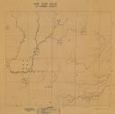
| Date: | 1939 |
|---|---|
| Description: | Map shows the locations and amount of game birds seen in Outagamie County. Natural landmarks are labelled. The bottom of the map contains a legend with sym... |
If you didn't find the material you searched for, our Library Reference Staff can help.
Call our reference desk at 608-264-6535 or email us at: