 Filter: Categories of Wisconsin Historical Images
Filter: FORMAT_TYPE of drawings
Filter: Year of 1800-1899
Filter: Categories of Wisconsin Historical Images
Filter: FORMAT_TYPE of drawings
Filter: Year of 1800-1899
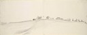
| Date: | 05 27 1849 |
|---|---|
| Description: | The wagon train crossing Laramie Creek in Wyoming. |
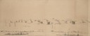
| Date: | 1849 |
|---|---|
| Description: | Fort Childs or New Fort Kearny in Nebraska Sketched by Wilkins on his 151-day journey from Missouri to California on the Overland Trail (also known as the ... |
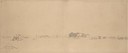
| Date: | 05 1849 |
|---|---|
| Description: | Deserted Pawnee village in Nebraska. Sketched by Wilkins on his 151-day journey from Missouri to California on the Overland Trail (also known as the Oregon... |
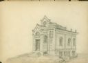
| Date: | 08 25 1885 |
|---|---|
| Description: | Gates of Heaven Synagogue. Designed by August Kutzbock. |

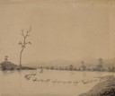
| Date: | 10 1852 |
|---|---|
| Description: | Landscape view of the river looking downstream from Fort Snelling, Minnesota Territory. An expanse of placid river water fills the center of the drawing an... |
| Date: | 05 1849 |
|---|---|
| Description: | Old Fort Kearney (Nebraska City). Sketched by Wilkins on his 151-day journey from Missouri to California on the Overland Trail (also known as the Oregon Tr... |
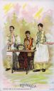
| Date: | 1892 |
|---|---|
| Description: | Chromolithograph card of a group of three men from Roumania [Romania] in "native" costume, posing next to a Singer sewing machine. Part of a "Costumes of A... |
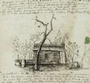
| Date: | 01 12 1844 |
|---|---|
| Description: | A pen and ink drawing of a log cabin, pork casks, and a washtub, contained in a letter written by Thomas Steel, Waukesha County farmer and physician, to hi... |

| Date: | 06 24 1849 |
|---|---|
| Description: | Original wash drawing of Fort Laramie, Wyoming (actually Fort John; see note below). Sketched by Wilkins on his 151-day journey from Missouri to California... |
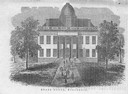
| Date: | 1856 |
|---|---|
| Description: | The Wisconsin State Capitol (the second State Capitol, the first in Madison). Illustration from the American Encyclopedia, Columbus, 1859. |

| Date: | 1833 |
|---|---|
| Description: | Township/section map showing Rodolf land and nearby neighbors. |

| Date: | 1834 |
|---|---|
| Description: | Peck-a-ton-oka (Pecatonica River) with Rodolf farm in the background. |
| Date: | 1876 |
|---|---|
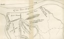
| Description: | A map of the site of the Battle of Point Pleasant. |
| Date: | 1863 |
|---|---|
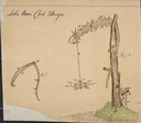
| Description: | Sketch of John Muir's clock design.The built clock was a combination of scythes, wheels and arrows. A rough bough of burr oak was set upon a base incrusted... |
| Date: | 1863 |
|---|---|
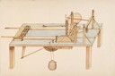
| Description: | A diagram of a table saw, designed and drawn by John Muir. |

| Date: | 1851 |
|---|---|
| Description: | Plat map of the Town of Madison (Township 7N, Range 9E), from Volume 4, Federal Survey Plat Books. |

| Date: | 1872 |
|---|---|
| Description: | The sidewheel packet, Red Wing, in the Mississippi River near Queen's Bluff below Trempealeau, Wisconsin. |

| Date: | 1855 |
|---|---|
| Description: | Detail from a lithograph vignette on a Map of the City of Madison of the third Wisconsin State Capitol, the first Capitol in Madison. |
| Date: | 1874 |
|---|---|
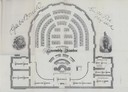
| Description: | Seating chart for members of the Wisconsin Assembly as published in the 1874 Legislative Manual, the Wisconsin Blue Book. |

| Date: | 02 21 1874 |
|---|---|
| Description: | African American boatmen run a rapids in a small river boat. |
If you didn't find the material you searched for, our Library Reference Staff can help.
Call our reference desk at 608-264-6535 or email us at: