Filter: Categories of Wisconsin Historical Images
Filter: FORMAT_TYPE of drawings
Filter: Categories of Wisconsin Historical Images
Filter: FORMAT_TYPE of drawings
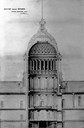
| Date: | 1857 |
|---|---|
| Description: | Section drawing of the rotunda of the third Wisconsin State Capitol (second in Madison) by Stephen V. Shipman. August Kutzbock and Samuel H. Donnel were th... |
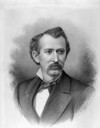
| Date: | 1880 |
|---|---|
| Description: | Charcoal portrait of George Baxter Burrows. A Wisconsin State Senator (1878-1882) and real estate broker, he willed his twelve-acre Lake Mendota frontage e... |
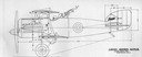
| Date: | 1918 |
|---|---|
| Description: | A design for the unbuilt "Lawson Battler," which Alfred Lawson conceived as an armored fighter plane armed with six machine guns. |

| Date: | 1918 |
|---|---|
| Description: | Advertisement for Lawson Aircraft during the period when the company was based in Green Bay and developing a military trainer. Lawson built several planes... |

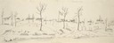
| Date: | 1852 |
|---|---|
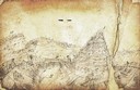
| Description: | Pencil drawing of Madison landscape as seen from University Hill. The main street in the center is State Street, and the building with Greek columns in the... |

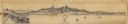
| Date: | 1852 |
|---|---|
| Description: | Pencil drawing of view overlooking Madison. The sketch looks down North Hamilton Street from the capitol. Rutted, irregular streets and frame houses mark ... |
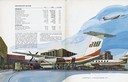
| Date: | 1979 |
|---|---|
| Description: | Illustration from the annual report of Air Wisconsin, the first publicly held airline in the country. Air Wisconsin began in Appleton in 1963 after North ... |
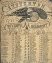
| Date: | |
|---|---|
| Description: | Hand-lettered Civil War commemorative roster of Company D, Seventh Wisconsin Infantry Regiment, known as the Stoughton Light Guard. The background is decor... |
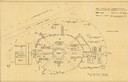
| Date: | 1951 |
|---|---|
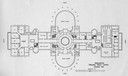
| Description: | The layout plan for the Lambertville Music Circus with elevations of stage and pit. |
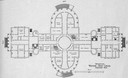
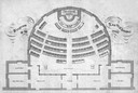
| Date: | 1904 |
|---|---|
| Description: | The floor plan of the first floor of the third Wisconsin Capitol as published in 1904 under the title "Program issued by the Capitol Improvement Commission... |
| Date: | 1904 |
|---|---|
| Description: | The floor plan of the second floor of the third Wisconsin Capitol as published in 1904 under the title "Program issued by the Capitol Improvement Commissio... |
| Date: | |
|---|---|
| Description: | Panoramic view from the south end of Lake Monona, looking north to the isthmus, with the 3rd Wisconsin State Capitol in the center, and St. Raphael's Cathe... |
| Date: | 1860 |
|---|---|
| Description: | Floor plan and seating chart for the Assembly for their first meeting in the East Wing of new Wisconsin State Capitol building. After the completion of th... |
| Date: | 05 1849 |
|---|---|
| Description: | Fort Leavenworth with trees, buildings and American flag. The fort was established by Colonel Henry Leavenworth to protect the Santa Fe trail against the I... |
| Date: | 1862 |
|---|---|
| Description: | Sketch of Boone's Knob and the Kentucky River, where Company A of the 22nd Wisconsin Infantry camped, November-December, 1862. The sketch was drawn by Priv... |
| Date: | |
|---|---|
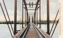
| Description: | Colorized view depicting the Wisconsin Central Railroad bridge at Stevens Point, with several men standing on top of the bridge painting the structure. Cap... |

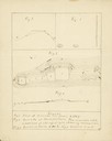
| Date: | 1790 |
|---|---|
| Description: | Map of the region surrounding Dayton, Ohio showing rivers and other settlements, with a table of distances from Cincinnati to Dayton and to points outside ... |
| Date: | 1875 |
|---|---|
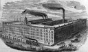
| Description: | Drawing of the C.H. & L.J. McCormick Reaper Manufactory (McCormick Reaper Works). The factory was built after the Chicago Fire of 1871 destroyed the origin... |

| Date: | 1833 |
|---|---|
| Description: | Map of part of the military road from Fort Crawford to Fort Howard. "Recorded on pages 668.669 Book B." Surveyed by Lieut. Center. Scale: 2 miles = 1 inch. |
If you didn't find the material you searched for, our Library Reference Staff can help.
Call our reference desk at 608-264-6535 or email us at: