Filter: Categories of Wisconsin Historical Images
Filter: FORMAT_TYPE of drawings
Filter: County of Iowa
Filter: Categories of Wisconsin Historical Images
Filter: FORMAT_TYPE of drawings
Filter: County of Iowa

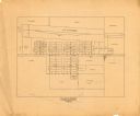
| Date: | 1840 |
|---|---|
| Description: | A hand-drawn plat map of Mineral Point, Wisconsin showing street layout and location of buildings. |
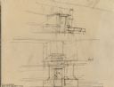
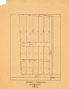
| Date: | |
|---|---|
| Description: | Sketch for Boiler Room Door, drawn by Frank Lloyd Wright, under the studio at Taliesin. The sketch shows two elevations and a floor plan. Taliesin is locat... |

| Date: | 1850 |
|---|---|
| Description: | Lithograph of a map drawn to indicate a mine on land owned by Mineral Point Mining Co. in the lead region of southwestern Wisconsin. |
| Date: | 1838 |
|---|---|
| Description: | Pencil sketch of a building owned by the Rodolf family along a commercial street. |
| Date: | 1838 |
|---|---|
| Description: | Pencil sketch of a stone house with a porch the full length of the dwelling, supported by 6 columns. |
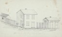
| Date: | 1838 |
|---|---|
| Description: | Pencil sketch of buildings, including the Post Office. |
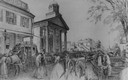
| Date: | 1859 |
|---|---|
| Description: | City Hall in the background of a bustling street, with pedestrians, horses, carriages, and wagons. A stagecoach is parked across the street on the left. |
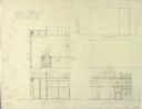
| Date: | |
|---|---|
| Description: | Pencil drawing showing the plan and elevations of the Japanese print vault in the studio at Taliesin, the summer home of architect Frank Lloyd Wright. Tali... |
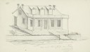
| Date: | 1946 |
|---|---|
| Description: | Pencil drawing (graphite and ink?) of Polperro House, at the Pendarvis State Historical Site in Mineral Point. Features a side gable entrance and a log fra... |

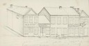
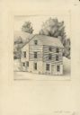
| Date: | 1946 |
|---|---|
| Description: | Pencil drawing of the Pendarvis and Trelawny Houses. Stone building with six over six windows on two levels, and three entrances. A stone wall runs along t... |
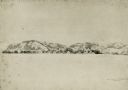
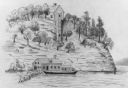
| Date: | 08 1852 |
|---|---|
| Description: | Pencil drawing of Rattlesnake Bluff and the town of Arena from a distance across a plain. A row of buildings runs along the foot of the gently rolling hill... |

| Date: | 07 02 1836 |
|---|---|
| Description: | An ink on paper, hand-drawn map shows the sections and streams in Township 5, Range 1 east, which covers parts of the present-day towns of Mifflin and Lind... |
| Date: | 1930 |
|---|---|
| Description: | This map is pen and pencil on paper and shows local streets, lots by number, and section divisions. |
| Date: | 1967 |
|---|---|
| Description: | This map is pen and pencil on paper and shows land ownership by name, blocks, lots, local streets, and railroads. To the right of the title the map reads: ... |
If you didn't find the material you searched for, our Library Reference Staff can help.
Call our reference desk at 608-264-6535 or email us at: