Filter: Categories of Wisconsin Historical Images
Filter: FORMAT_NUMBER_ORG of PH 7051
Filter: Type of Map or Atlas
Filter: Categories of Wisconsin Historical Images
Filter: FORMAT_NUMBER_ORG of PH 7051
Filter: Type of Map or Atlas

| Date: | 1909 |
|---|---|
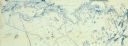
| Description: | A hand-drawn and illustrated map of The Gang's trip from their seventh camp to Lake Superior. |

| Date: | |
|---|---|
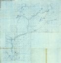
| Description: | A blueprint of a map of a portion of Ashland County. |

| Date: | |
|---|---|
| Description: | A blueprint map of a portion of Chippewa County. |
| Date: | |
|---|---|
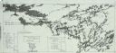
| Description: | A detailed blueprint map showing the route of Howard Greene and The Gang's canoe trip through the Rainy Lake region in 1910. |
| Date: | 1911 |
|---|---|
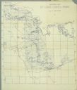
| Description: | A map of St. Louis County, Minnesota that traces the route of Howard Green and The Gang's canoe trip from Tower to Ranier. |
| Date: | |
|---|---|
| Description: | A blueprint map with an overlay traced in pencil of the routes of Howard Greene and The Gang's 1910 and 1911 canoe trips. |
If you didn't find the material you searched for, our Library Reference Staff can help.
Call our reference desk at 608-264-6535 or email us at: