 Filter: Categories of Wisconsin Historical Images
Filter: FORMAT_NUMBER_ORG of PH 6445
Filter: Categories of Wisconsin Historical Images
Filter: FORMAT_NUMBER_ORG of PH 6445

| Date: | 03 20 1985 |
|---|---|
| Description: | Green Lake CTH FF with a barn and a farmhouse in the distance, a mobile home, and an abandoned log cabin. A closer view of the log cabin can be seen in Ima... |

| Date: | 03 20 1985 |
|---|---|
| Description: | Log cabin on Green Lake County Highway FF, also seen in Image 36120. |

| Date: | 03 20 1985 |
|---|---|
| Description: | A barn located on Green Lake CTH FF near Belle Fountain Creek partially destroyed by fire reaving its method of construction. This structure was located im... |

| Date: | 09 13 1983 |
|---|---|
| Description: | Farm located on Green Lake County highway FF near Belle Fountain Creek. This image shows the log cabin also seen in Image #36120 & #36121, and the barn in... |

| Date: | 11 05 1986 |
|---|---|
| Description: | Green Lake County Highway M meandering toward a red barn in the distance on a November day, an archtypal Wisconsin landscape. |
| Date: | 03 21 1986 |
|---|---|
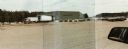
| Description: | Office and metal warehouse of Potato World, Inc., located on County Highway E near Grand Marsh in Adams County. |

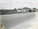
| Date: | 11 1957 |
|---|---|
| Description: | Photograph taken by the State Highway Department to show the condition of curbs and gutters along STH 12 in Mauston, also documenting the original brick su... |
| Date: | 1957 |
|---|---|
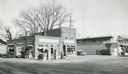
| Description: | Skelly service station, restaurant, and motel located along STH 12 in Mauston, Wisconsin. |
| Date: | |
|---|---|
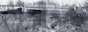
| Description: | Bridge over the Yellow River on County Highway BB in Wood County. |
| Date: | 12 12 1973 |
|---|---|
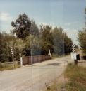
| Description: | Neenah Creek Bridge in Marquette County. |

| Date: | 11 29 1989 |
|---|---|
| Description: | Old bridge over Mill Creek on Highway G in Portage County. |

| Date: | 10 11 1973 |
|---|---|
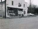
| Description: | On a rainy day a Gardners' Bakery truck makes a delivery to Miller's Corner IGA Grocery Store on STH 153. |
| Date: | 07 26 1967 |
|---|---|
| Description: | Buildings of the Gumz muck farm, near Packwaukee, Wisconsin. |

| Date: | 05 21 1968 |
|---|---|
| Description: | Rural tavern and gasoline station on STH 54. |
| Date: | 1967 |
|---|---|
| Description: | Waupaca Tree Service at the intersection of STH 24 and King Road with station wagon parked in front. |
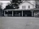
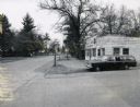
| Date: | 1967 |
|---|---|
| Description: | King's Koffee Kup, a restaurant located on STH 22. |
| Date: | 1967 |
|---|---|
| Description: | Bungalow-style house located on STH 22, that had been converted into a beer garden and bait shop. |
| Date: | 1967 |
|---|---|
| Description: | Carlson's One Stop Market located on STH 22. |
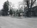
| Date: | 1967 |
|---|---|
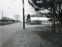
| Description: | Handle's Bar and Motel, located along STH 22 in King, Wisconsin, at the intersection with Grand View Road. Another motel can be seen in the distance acros... |
If you didn't find the material you searched for, our Library Reference Staff can help.
Call our reference desk at 608-264-6535 or email us at:
