 Filter: Categories of Wisconsin Historical Images
Filter: FORMAT_DIMENSIONS of 22 x 17 inches
Filter: Subject of transportation
Filter: Categories of Wisconsin Historical Images
Filter: FORMAT_DIMENSIONS of 22 x 17 inches
Filter: Subject of transportation

| Date: | 1871 |
|---|---|
| Description: | Birds eye map of Brodhead, WI depicts street names and street locations, houses, and trees. A reference key at the bottom of the map shows the locations of... |

| Date: | 1875 |
|---|---|
| Description: | Bird's-eye map of Richland Center. |
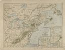
| Date: | 1610 |
|---|---|
| Description: | A map of New France, including parts of the United States and Canada, to illustrate the Jesuit relations and allied documents. There is some handwriting an... |
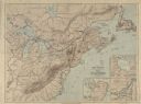
| Date: | 1610 |
|---|---|
| Description: | A map of New France, including parts of the United States and Canada, to illustrate the Jesuit relations and allied documents. |
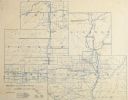
| Date: | 1896 |
|---|---|
| Description: | Section 9 of 12, this bicycle road map features Wisconsin bicycle routes in the counties of Taylor, Marathon, Lincoln, and Price. |
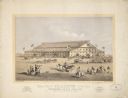
| Date: | 1869 |
|---|---|
| Description: | A lithograph of the Coliseum for the Grand National Peace Jubilee in Boston, Massachusetts on June 15-19. |
If you didn't find the material you searched for, our Library Reference Staff can help.
Call our reference desk at 608-264-6535 or email us at:
