 Filter: Categories of Wisconsin Historical Images
Filter: FORMAT_DIMENSIONS of 21.5 x 25 inches
Filter: Year of 1800-1899
Filter: Categories of Wisconsin Historical Images
Filter: FORMAT_DIMENSIONS of 21.5 x 25 inches
Filter: Year of 1800-1899
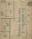
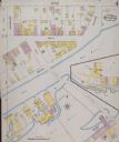
| Date: | 08 1884 |
|---|---|
| Description: | Sheet 1 of a Sanborn map of a portion of Mineral Point. |

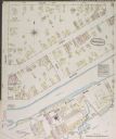
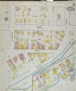
| Date: | 08 1884 |
|---|---|
| Description: | Sheet 2 of a Sanborn map of a portion of Mineral Point. |

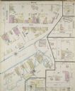
| Date: | 04 1889 |
|---|---|
| Description: | Sheet 1 of a Sanborn map of a portion of Mineral Point. |

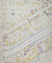
| Date: | 04 1889 |
|---|---|
| Description: | Sheet 2 of a Sanborn map of a portion of Mineral Point. |

| Date: | 04 1889 |
|---|---|
| Description: | Sheet 4 of a Sanborn map of a portion of Mineral Point. |

| Date: | 07 1894 |
|---|---|
| Description: | Sheet 5 of a Sanborn map of a portion of Mineral Point. |
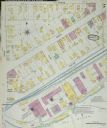
| Date: | 1884 |
|---|---|
| Description: | Sanborn-Perris fire insurance map for city of Menasha. |
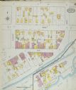
| Date: | 1884 |
|---|---|
| Description: | Sanborn-Perris fire insurance map for city of Menasha. |
| Date: | 1887 |
|---|---|
| Description: | Sanborn-Perris fire insurance maps for city of Menasha. |
| Date: | 1887 |
|---|---|
| Description: | Sanborn-Perris fire insurance maps for city of Menasha. |
| Date: | 1891 |
|---|---|
| Description: | Sanborn-Perris fire insurance maps for city of Menasha. |
| Date: | 1891 |
|---|---|
| Description: | Sanborn-Perris fire insurance maps for city of Menasha. |
| Date: | 1895 |
|---|---|
| Description: | Sanborn-Perris fire insurance maps for city of Menasha. |
| Date: | 1895 |
|---|---|
| Description: | Sanborn-Perris fire insurance maps for city of Menasha. |

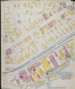
| Date: | 1894 |
|---|---|
| Description: | Sanborn map of a portion of Milwaukee, including St. Clair and Bishop and Potter Avenues. There is an inset for the South Side Wood Working Co. |

| Date: | 1894 |
|---|---|
| Description: | Sanborn Map of the Illinois Steel Co. Bay View Works in Milwaukee. |

| Date: | 1885 |
|---|---|
| Description: | A detail of a Sanborn map showing the lake Mendota shore area, including Madison Manufacturing Company. |
If you didn't find the material you searched for, our Library Reference Staff can help.
Call our reference desk at 608-264-6535 or email us at: