Filter: Categories of Wisconsin Historical Images
Filter: County of Wood
Filter: Type of Map or Atlas
Filter: Categories of Wisconsin Historical Images
Filter: County of Wood
Filter: Type of Map or Atlas

| Date: | 1874 |
|---|---|
| Description: | Bird's-eye map of Grand Rapids. |

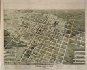
| Date: | 1883 |
|---|---|
| Description: | Bird's-eye map of Marshfield, with one vignette. |
| Date: | 1891 |
|---|---|
| Description: | Bird's-eye map of Marshfield, looking north, with six vignettes of east and west side of Central Ave, between 3rd and 4th, 2nd and 3rd, and Railroad and 2n... |

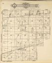
| Date: | 1878 |
|---|---|
| Description: | This 1878 map of Wood County, Wisconsin, shows the township and range grid, towns, sections, cities, villages and post offices, landownership, roads, railr... |

| Date: | 1902 |
|---|---|
| Description: | This map from the early years of the 20th century shows the township and range grid, sections, cities and villages, landownership, roads and railroads, and... |

| Date: | 1910 |
|---|---|
| Description: | This early 20th century map of Wood County, Wisconsin, shows the township and range grid, towns, sections, cities and villages, roads and railroads, and st... |

| Date: | 1892 |
|---|---|
| Description: | 1 map on 4 sheets : col., mounted on cloth ; Shows landownership, roads and railroads, townships, and selected buildings. Includes "Professional directory... |

| Date: | 1858 |
|---|---|
| Description: | Map showing roads, mills, and rivers. Date conjectured from presence of Ensign’s Mill and Pitt’s Mill and location of Nekoosa. |

| Date: | 06 22 1891 |
|---|---|
| Description: | This 1891 manuscript map depicts Cranberry Creek and wetlands in part of the Town of Port Edwards, Wood County, Wisconsin. Elevations and falls in the cree... |

| Date: | 1992 |
|---|---|
| Description: | This 1992 map of Wood County, Wisconsin, shows towns, sections, cities and villages, highways and roads, railroads, and lakes and streams. An inset map of ... |

| Date: | 06 1931 |
|---|---|
| Description: | This map is a photocopy of a map that has been hand-colored and shows streets, the Wisconsin River, Mill Pond, and points of interest that include a school... |
If you didn't find the material you searched for, our Library Reference Staff can help.
Call our reference desk at 608-264-6535 or email us at: