 Filter: Categories of Wisconsin Historical Images
Filter: County of Waukesha
Filter: Type of Map or Atlas
Filter: Categories of Wisconsin Historical Images
Filter: County of Waukesha
Filter: Type of Map or Atlas

| Date: | 1885 |
|---|---|
| Description: | Bird's-eye map of Oconomowoc. |

| Date: | 1886 |
|---|---|
| Description: | Bird's-eye map of Menomonee Falls. |

| Date: | 1857 |
|---|---|
| Description: | Elevated view of Waukesha with two women wearing dresses with a boy in long pants and tam o'shanter hat in foreground against a split-rail fence. Beyond th... |

| Date: | 1880 |
|---|---|
| Description: | Bird's-eye map of Waukesha, county seat of Waukesha County. |

| Date: | 1870 |
|---|---|
| Description: | Birds-eye drawing of Oconomowoc depicts street names and street layouts, houses, trees, Oconomowoc River, Fowler Lake, and La Belle Lake. A reference key a... |

| Date: | 1874 |
|---|---|
| Description: | Bird's-eye view of Waukesha, looking southwest, with insets of State Industrial School, Court House, and Fountain Spring House. |

| Date: | 1890 |
|---|---|
| Description: | Colored bird's-eye map of Oconomowoc and the Lake Region, Waukesha County. Looking North from Government Hill. Location key below image identifies 24 Hotel... |
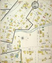
| Date: | 10 1914 |
|---|---|
| Description: | Page 2 of a Sanborn-Perris map of Pewaukee. |
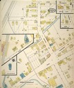
| Date: | 07 1924 |
|---|---|
| Description: | Page 3 of Sanborn-Perris map of Pewaukee. |
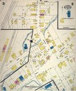
| Date: | 11 1899 |
|---|---|
| Description: | Page 1 of Sanborn-Perris map of Pewaukee. |
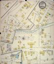
| Date: | 10 1894 |
|---|---|
| Description: | Page 1 of Sanborn-Perris map of Pewaukee. |

| Date: | 11 14 1942 |
|---|---|
| Description: | This pictorial map illustrates Potawatomi Indian legends from the region of Lower Phantom Lake, labeled Howitt Lake on the map, Phantom Lake, and Mukwonag... |

| Date: | 1882 |
|---|---|
| Description: | This manuscript map from 1882 shows land use and land for sale in a portion of the Town of Pewaukee, Waukesha County, Wisconsin. Woods, marshland, springs,... |

| Date: | |
|---|---|
| Description: | This 19th century manuscript map of the Town of Oconomoc, Waukesha County, Wisconsin, is drawn on a printed township grid. It shows landownership and lakes... |

| Date: | 1873 |
|---|---|
| Description: | This late 19th century map shows the lake region around Oconomowoc in Waukesha County and eastern Jefferson County, Wisconsin. The township and range grid,... |

| Date: | 1934 |
|---|---|
| Description: | This map of Waukesha County, Wisconsin, from the Wisconsin Land Inventory shows the township and range grid, sections, cities and villages, vegetation type... |

| Date: | 1953 |
|---|---|
| Description: | Map shows landownership and acreages, roads, and railroads in the Town of Waukesha and part of the city of Waukesha, Waukesha County, Wisconsin. |

| Date: | 02 1956 |
|---|---|
| Description: | This 1956 map of Waukesha County, Wisconsin, shows the township and range grid, towns, sections, cities and villages, roads, railroads, dams, airports, par... |

| Date: | 1891 |
|---|---|
| Description: | This late 19th century map shows the lake region around Oconomowoc in Waukesha County and eastern Jefferson County, Wisconsin. The township and range grid,... |
If you didn't find the material you searched for, our Library Reference Staff can help.
Call our reference desk at 608-264-6535 or email us at:
