Filter: Categories of Wisconsin Historical Images
Filter: County of Taylor
Filter: Subject of human settlements
Filter: Categories of Wisconsin Historical Images
Filter: County of Taylor
Filter: Subject of human settlements
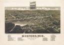
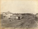
| Date: | 1885 |
|---|---|
| Description: | Bird's-eye map of Medford, before the great fire of May 28, 1885. |
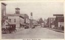
| Date: | |
|---|---|
| Description: | State Street in Medford. Caption reads: "State Street, Medford, Wis." |
| Date: | |
|---|---|
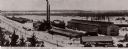
| Description: | The U.S. Leather Co. tannery in Medford. Caption reads: "U.S. Leather Co. Tannery, Medford, Wis." |
| Date: | 1979 |
|---|---|
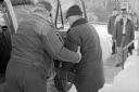
| Description: | The driver helps a senior citizen board the bus after a lunch at the Medford Senior Center. |

| Date: | 1895 |
|---|---|
| Description: | The front (top) and back (bottom) of a promotional card advertising the large amounts of hemlock bark in Northern Wisconsin. The image shows three men sitt... |

| Date: | 1895 |
|---|---|
| Description: | A promotional card displaying a populated village street near a lake in Northern Wisconsin. The caption bellow the photography reads: "RIB LAKE, TAYLOR C... |
| Date: | 1895 |
|---|---|
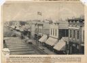
| Description: | Promotional card created to advertize land in northern Wisconsin Caption: STREET SCENE IN MEDFORD, TAYLOR COUNTY, WISCONSIN. - This view of one of the bu... |

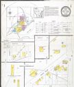
| Date: | 1887 |
|---|---|
| Description: | This 1887 map of Taylor County, Wisconsin, shows the township and range system, sections, railroads, vacant Wisconsin Central Railroad land, land sold by t... |

| Date: | 1887 |
|---|---|
| Description: | This 1896 map shows the township and range system, sections, cities and villages, railroads, roads, vacant land and land sold by the Wisconsin Central Rail... |

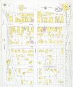
| Date: | 1909 |
|---|---|
| Description: | This 1909 map of Taylor County, Wisconsin, shows the township and range grid, towns, sections, cities and villages, settlers houses, schools, churches, saw... |

| Date: | |
|---|---|
| Description: | This map of Taylor County, Wisconsin, shows soil types, the township and range grid, sections, settlers houses, schools, churches, saw mills, tanneries, ro... |

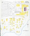
| Date: | 1940 |
|---|---|
| Description: | This map of Taylor County, Wisconsin, shows the township and range grid, towns, sections, cities and villages, railroads, roads, creameries and cheese fact... |
| Date: | 05 10 1960 |
|---|---|
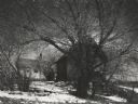
| Description: | View through the trees of an abandoned farm. |
If you didn't find the material you searched for, our Library Reference Staff can help.
Call our reference desk at 608-264-6535 or email us at: