 Filter: Categories of Wisconsin Historical Images
Filter: County of Sawyer
Filter: Type of Map or Atlas
Filter: Categories of Wisconsin Historical Images
Filter: County of Sawyer
Filter: Type of Map or Atlas

| Date: | 1919 |
|---|---|
| Description: | This is a collection of three hand-colored plat maps. One map is a plat plan and includes annotations and an index that shows public land, business, indust... |

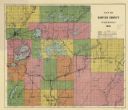
| Date: | 1909 |
|---|---|
| Description: | Map of Sawyer County with an advertisement for land sales through Fuley & Quail of Hayward, Wisconsin. There is a small inset map of railroads accessible i... |

| Date: | 1923 |
|---|---|
| Description: | This map from the Wisconsin Lakes and Parks Association shows the area of a proposed state park, much of which is now part of the Flambeau River State Fore... |
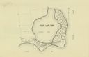
| Date: | |
|---|---|
| Description: | This map shows the lots surrounding Hinton Bay on Round Lake in the Town of Hayward, Sawyer County, Wisconsin. |

| Date: | 1920 |
|---|---|
| Description: | This map of Sawyer County, Wisconsin, from the early 20th century shows the township and range system, towns, sections, cities and villages, railroads, hig... |

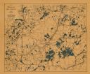
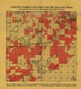
| Date: | 1897 |
|---|---|
| Description: | This 1897 map of Sawyer County, Wisconsin, shows the township and range system, sections, roads, farm houses, camps, school houses, dams, bridges, Indian r... |

| Date: | 1898 |
|---|---|
| Description: | This 1898 map of Sawyer County, Wisconsin, shows the township and range system, sections, roads, farm houses, camps, school houses, dams, bridges, Indian r... |

| Date: | 1900 |
|---|---|
| Description: | This map of Sawyer County, Wisconsin, shows the numbered "sub-school-districts of the town of Hayward" school houses, and the Indian reservation. The towns... |

| Date: | 1902 |
|---|---|
| Description: | This 1902 map of the eastern portion of Sawyer County, Wisconsin, shows the township and range system, sections, roads, farm houses, camps, school houses, ... |

| Date: | 1911 |
|---|---|
| Description: | This 1911 map of south central Sawyer County, Wisconsin, shows land for sale by Veness & Kasl of Exeland, the township and range system, sections, homes, r... |

| Date: | 1919 |
|---|---|
| Description: | This 1919 map of Sawyer County, Wisconsin, shows the township and range system, sections, cities and villages, roads, railroads, farm houses, the Indian re... |

| Date: | 1925 |
|---|---|
| Description: | This 1925 map of the northern portion of Sawyer County, Wisconsin, shows the township and range system, sections, roads, railroads, and lakes and streams i... |

| Date: | 1926 |
|---|---|
| Description: | This 1926 map of Sawyer County, Wisconsin, the township and range system, towns, sections, cities and villages, railroads, highways and roads, and lakes an... |

| Date: | 1927 |
|---|---|
| Description: | This 1927 map of Sawyer County, Wisconsin, shows the township and range system, sections, cities and villages, roads, railroads, and lakes and streams. |
| Date: | 1931 |
|---|---|
| Description: | This 1931 map of Sawyer County, Wisconsin, shows the township and range system, towns, sections, cities and villages, railroads, highways and roads, and la... |
| Date: | 1940 |
|---|---|
| Description: | This map shows cities and villages, roads, railroads, and lakes and streams in northern Sawyer, northeastern Washburn, southeastern Douglas, and southern B... |

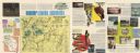
| Date: | 1949 |
|---|---|
| Description: | This 1949 tourism brochure for the Hayward region includes a directory of members of the Hayward Lakes Resort Association, color illustrations, descriptive... |
| Date: | 1968 |
|---|---|
| Description: | This 1960s tourism brochure for Sawyer County, Wisconsin, includes descriptive text, color illustrations, a road map, a distance map, a location map, and l... |

| Date: | |
|---|---|
| Description: | This map shows the township and range system, sections, dam locations, railroads, roads, selected buildings, and lakes and streams in Sawyer County, Wiscon... |
| Date: | 1920 |
|---|---|
| Description: | This early-20th century map of the towns of Round Lake and Spider Lake, Sawyer County, Wisconsin, shows sections, roads, lake and streams, and land owned a... |
If you didn't find the material you searched for, our Library Reference Staff can help.
Call our reference desk at 608-264-6535 or email us at: