 Filter: Categories of Wisconsin Historical Images
Filter: County of Polk
Filter: Categories of Wisconsin Historical Images
Filter: County of Polk

| Date: | 1898 |
|---|---|
| Description: | A man carries a canoe on his shoulders while portaging through a thickly-wooded area. |

| Date: | 1880 |
|---|---|
| Description: | Stereograph of the Dalles and the Saint Croix River with man in the foreground. |

| Date: | |
|---|---|
| Description: | Clam Lake artist Jerry Holter carving a wooden portrait of John A. Lavine, a Wisconsin newspaper publisher. |
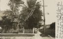
| Date: | 1908 |
|---|---|
| Description: | Photographic postcard view of Harriman Avenue in the residential district. A little girl is standing with her baby carriage on the sidewalk between a telep... |

| Date: | |
|---|---|
| Description: | Color photographic postcard of three people navigating a red canoe through yellow water lilies in Woodley's Dam near Highway 8 and 46, north of Amery. Capt... |

| Date: | |
|---|---|
| Description: | Color photographic postcard of a man in a fishing boat on Woodley's Dam north of Amery. View of the dammed water surrounded by pine trees. Caption reads: "... |
| Date: | 1929 |
|---|---|
| Description: | Oscar Steinkopf and his horse Jim. They are haying on Steinkopf's 40-acre farm. The photograph was taken by Alvin Steinkopf, Oscar's son, a Milwaukee journ... |
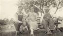
| Date: | 1929 |
|---|---|
| Description: | Alvin Steinkopf (left), a Milwaukee journalist, dressed for work on the farm of his parents, Mathilda and Oscar Steinkopf. The Steinkopfs farmed 40 acres n... |

| Date: | 1929 |
|---|---|
| Description: | Oscar Steinkopf feeding the chickens on his 40-acre farm near Luck. Feeding the chickens was traditionally considered women's work and perhaps Steinkopf wa... |
| Date: | |
|---|---|
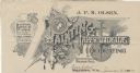
| Description: | Letterhead of J.P.M. Olsen, painter, paper-hanger, and decorator from Durholm, Wisconsin (previously of Milltown, Wisconsin). There is a profile image of a... |

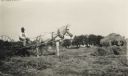
| Date: | 09 09 1895 |
|---|---|
| Description: | View across field of two men leaning against an enormous stack of grain on the farm of August Schmidt. There are many more stacks of grain leading into the... |

| Date: | 09 27 1895 |
|---|---|
| Description: | In the cornfield of Jas. E. Seed, a number of large, yellow "Yankee" pumpkins ripen on vines. A man is crouched in the field, holding a pumpkin in his arms... |

| Date: | 1895 |
|---|---|
| Description: | A man stands with fifty beehives on the farm of Bernhard Volkering in East Farmington. Trees and farm buildings surround the hives. |

| Date: | 1926 |
|---|---|
| Description: | A brochure with a map of Interstate Park on the Dalles of the Saint Croix River, showing locations of the north and south camp grounds, the fish hatcheries... |
| Date: | 1980 |
|---|---|
| Description: | This road map of Polk County, Wisconsin, has been annotated to show the location of historic sites in the county and is accompanied by a 1980 directory of ... |
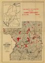
| Date: | 1900 |
|---|---|
| Description: | This map of Polk County, Wisconsin, from the early 20th century shows the land for sale by the Cushing Land Agency of Saint Croix Falls. The township and r... |

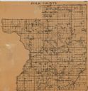
| Date: | 1911 |
|---|---|
| Description: | This map of Polk County, Wisconsin, from the early 20th century shows the land for sale by the Baker Land and Title Co. of Saint Croix Falls. The township ... |

| Date: | |
|---|---|
| Description: | This map from the early 20th century shows the township and range grid, towns, sections, cities and villages, railroads, roads, schools, churches, and stre... |
| Date: | |
|---|---|
| Description: | This map of Polk County, Wisconsin, from the first half of the 20th century, shows the township and range grid, towns, sections, villages, roads, railroads... |

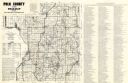
| Date: | 1901 |
|---|---|
| Description: | Map shows townships, schools, creameries, post offices, and roads. The left side of the map features a legend with symbols for points of interest. |
If you didn't find the material you searched for, our Library Reference Staff can help.
Call our reference desk at 608-264-6535 or email us at: