 Filter: Categories of Wisconsin Historical Images
Filter: County of Pepin
Filter: Type of Map or Atlas
Filter: Categories of Wisconsin Historical Images
Filter: County of Pepin
Filter: Type of Map or Atlas

| Date: | 1887 |
|---|---|
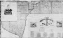
| Description: | This 1887 manuscript map by Amidon G. Miller covers portions of the towns of Nelson and Stockholm in Pepin County, Wisconsin, as well as a portion of the T... |

| Date: | 1913 |
|---|---|
| Description: | This 1913 map of Pepin County, Wisconsin, shows the township and range grid, towns, villages, rural routes, railroads, roads, schools, churches, cemeteries... |

| Date: | 1922 |
|---|---|
| Description: | This map of Pepin County, Wisconsin, from the first half of the 20th century shows the township and range grid, towns, villages, railroads, roads, schools,... |

| Date: | 1887 |
|---|---|
| Description: | This etching by Amidon G. Miller covers portions of the towns of Nelson and Stockholm in Pepin County, Wisconsin, as well as a portion of the Town of Maide... |

| Date: | 1850 |
|---|---|
| Description: | This series of maps shows townships, ranges, sections, lakes, rivers, and roads. The maps cover areas between Township No. 26 and Township No. 42. |
| Date: | 1990 |
|---|---|
| Description: | This map shows the town boundaries, Lake Pepin, and landownership in the county. The map includes a business directory, statistics and distances tables, an... |
| Date: | 1896 |
|---|---|
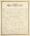
| Description: | A plat map of the township of Lima in Pepin County. |
If you didn't find the material you searched for, our Library Reference Staff can help.
Call our reference desk at 608-264-6535 or email us at: