 Filter: Categories of Wisconsin Historical Images
Filter: County of Menominee
Filter: Type of Map or Atlas
Filter: Categories of Wisconsin Historical Images
Filter: County of Menominee
Filter: Type of Map or Atlas
| Date: | 1974 |
|---|---|
| Description: | This map is a 9 part map detailing various parts of Menominee County, Wisconsin. Page 1 of the map shows federal aid control in the county and was used by ... |

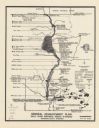
| Date: | 1947 |
|---|---|
| Description: | Shows lot and block numbers, 28 points of interest in the upper left that correspond to numbers on the map, and landownership with acreages. "Erickson Brot... |

| Date: | 1956 |
|---|---|
| Description: | This map shows reservation boundaries, U.S. township lines, highways, roads, rivers, and lakes. The lower left corner of the map includes a legend of "Conv... |

| Date: | 1970 |
|---|---|
| Description: | This map shows land owned by Menominee Enterprise Inc., land sold to Menominee shareholders, and land sold to non-Menominees. The map also includes water a... |
If you didn't find the material you searched for, our Library Reference Staff can help.
Call our reference desk at 608-264-6535 or email us at: