 Filter: Categories of Wisconsin Historical Images
Filter: County of Marquette
Filter: Type of Map or Atlas
Filter: Categories of Wisconsin Historical Images
Filter: County of Marquette
Filter: Type of Map or Atlas
| Date: | |
|---|---|
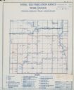
| Description: | Rural electrification survey map of Marquette county in Westfield township. |

| Date: | 1883 |
|---|---|
| Description: | Bird's-eye view of Montello, county seat of Marquette County. The granite quarry, woolen mill, and planing mill are clearly identified. A steamboat on Buf... |
| Date: | |
|---|---|
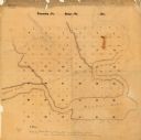
| Description: | This manuscript map shows the township and range system and lakes and streams in the vicinity of the Fox River, Puckaway Lake, and Buffalo Lake in the town... |
| Date: | 1876 |
|---|---|
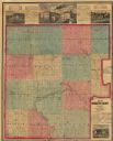
| Description: | Map shows townships and sections, landownership and acreages, roads, railroads, and selected rural buildings. Sections are shown in green, blue, and red. T... |
If you didn't find the material you searched for, our Library Reference Staff can help.
Call our reference desk at 608-264-6535 or email us at:

