 Filter: Categories of Wisconsin Historical Images
Filter: County of Kewaunee
Filter: Year of 1800-1899
Filter: Categories of Wisconsin Historical Images
Filter: County of Kewaunee
Filter: Year of 1800-1899
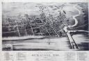
| Date: | 1893 |
|---|---|
| Description: | Bird's-eye map of Kewaunee, with inset of The Kewaunee and Frankfort Car Ferry Line. |
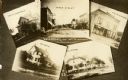
| Date: | 1890 |
|---|---|
| Description: | A collage of scenic views of Luxemburg. |
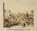
| Date: | 07 1886 |
|---|---|
| Description: | Intersection of 4th and Steele Streets facing east. The building in the lower right is the Knipfer building, now Algoma Mercantile. Bunting adorns the Boed... |

| Date: | 1876 |
|---|---|
| Description: | This 1876 map shows the mouth of the Ahnapee River at Algoma, Kewaunee County, Wisconsin, with soundings given in tenths of a foot. Proposed improvements a... |

| Date: | 1876 |
|---|---|
| Description: | Map shows townships and sections, landownership and acreages, roads, railroads, post offices, and farms. Sections appear in pink, yellow, and blue. On the ... |

| Date: | 1840 |
|---|---|
| Description: | This map of Kewaunee shows lot and block numbers, Lake Michigan, and includes a location map showing proposed railroads. The map includes manuscript annota... |

| Date: | 1892 |
|---|---|
| Description: | A group of six men in the dining hall of a lumber camp. The men are in a room with long tables filled with table settings. |
If you didn't find the material you searched for, our Library Reference Staff can help.
Call our reference desk at 608-264-6535 or email us at: