Filter: Categories of Wisconsin Historical Images
Filter: County of Juneau
Filter: Type of Map or Atlas
Filter: Categories of Wisconsin Historical Images
Filter: County of Juneau
Filter: Type of Map or Atlas

| Date: | 1926 |
|---|---|
| Description: | This hand-colored blueprint map shows landowners in part of T15N, R5E in Juneau County. North is oriented to the right. |

| Date: | 1935 |
|---|---|
| Description: | Map of Juneau County showing area zoned for reforestation shaded in red. |
| Date: | 1900 |
|---|---|
| Description: | Map showing the layout of the Wisocnisn Military Reservation, including buildings, rifle ranges, highways, railways, and geographic landmarks. |
| Date: | 1965 |
|---|---|
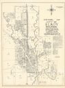
| Description: | Shows city limits, plat of town, local streets, railroads, and Baraboo River. "Revised by Mid-State Associates, Baraboo, Wisconsin, April 6, 1965" Upper ri... |
| Date: | 1912 |
|---|---|
| Description: | Map shows roads, railroads, post offices, schools, houses, churches, routes, and post office collection boxes. The map includes a distant chart and explana... |
| Date: | 1947 |
|---|---|
| Description: | Map includes a legend identifying four types of runway lights for aircraft, and a building index. The map includes an inset of the site and location plan. ... |

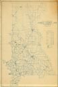
| Date: | 1876 |
|---|---|
| Description: | A hand-colored map on six sheets, this map of Juneau County indicates the locations of townships and sections, landowners and acreages, roads, wagon roads,... |

| Date: | 1879 |
|---|---|
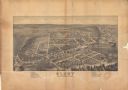
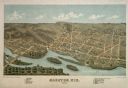
| Description: | This bird’s-eye-view map is a photostat copy of the orginal and is indexed for points of interest. Streets are labeled as well as the Barbaoo River. |

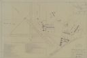
| Date: | |
|---|---|
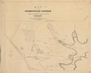
| Description: | This plat map shows numbered blocks and lots, local streets, the La Crosse and Milwaukee Railroad, and part of the Lemonwier [i.e. Lemonweir] River. |

| Date: | 1958 |
|---|---|
| Description: | This blue line print map shows lot and block numbers and dimensions, additions, and some landownership. The Lawrence River is labeled. |

| Date: | 1914 |
|---|---|
| Description: | Pg. 44 West Half of Marion Township. Pg. 45 East Half of Marion Township. |

| Date: | 1914 |
|---|---|
| Description: | A farmer's directory of Marion Township listing farmers and locations of their farms. |
If you didn't find the material you searched for, our Library Reference Staff can help.
Call our reference desk at 608-264-6535 or email us at: