 Filter: Categories of Wisconsin Historical Images
Filter: County of Iron
Filter: Year of 1800-1899
Filter: Categories of Wisconsin Historical Images
Filter: County of Iron
Filter: Year of 1800-1899

| Date: | 1886 |
|---|---|
| Description: | Bird's-eye map of Hurley with insets Mining at the Colby, Hurley in 1885, and North Front of Silver Street. |
| Date: | 1886 |
|---|---|
| Description: | Outdoor group portrait of the Gogebic Range iron miners. |
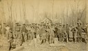
| Date: | 1885 |
|---|---|
| Description: | Burton House, (also referred to as the Ridge House by Edna Ferber in her novel, "Come and Get It") with horse-drawn carriages in the foreground. |

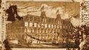
| Date: | 1887 |
|---|---|
| Description: | Benedict & Co. engineers. As shown by development to March 1st 1887. Inset: Map of northern Wisconsin showing location of range. Lands in red. |
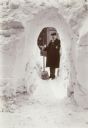
| Date: | 03 1899 |
|---|---|
| Description: | Winter scene of man wearing an overcoat and hat stands with a shovel at the far end of a snow tunnel shoveled through a tall snowbank. |

| Date: | 09 27 1895 |
|---|---|
| Description: | Elevated view of men and horses standing atop the platform used to load wood into charcoal kilns, also known as pits. These kilns convert cord wood into ch... |
| Date: | 09 27 1895 |
|---|---|
| Description: | A plot of land in front of a row of houses features cabbage in the foreground, ripe, four-foot tall Havana seed leaf tobacco plants in the center, and swee... |

| Date: | 1896 |
|---|---|
| Description: | A map of Iron County, Wisconsin, shows vacant Wisconsin Central Rail Road lands, settlers houses, land sold by Wisconsin Central R.R., schools, churches, s... |

| Date: | 1898 |
|---|---|
| Description: | A map of Iron County, Wisconsin, shows vacant Wisconsin Central Rail Road lands, settlers houses, land sold by Wisconsin Central R.R., schools, churches, s... |

| Date: | 09 1891 |
|---|---|
| Description: | Sanborn map of Hurley, featuring the Village of Gile and the Montreal River Lumber Company. |

| Date: | 1898 |
|---|---|
| Description: | Sanborn map of Hurley featuring the Village of Gile. |

| Date: | 02 1898 |
|---|---|
| Description: | Sanborn map of Hurley featuring the Montreal Mining Company. |

| Date: | 1892 |
|---|---|
| Description: | This map shows rivers, lakes, railroad lines, roads, and communities in addition to geological data. The map includes cross-sections in the bottom margin a... |

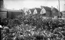
| Date: | 1887 |
|---|---|
| Description: | A view of the businesses present on Silver Street, Hurley's main street, less than three years after the city's settlement. City residents and a horse-dra... |
If you didn't find the material you searched for, our Library Reference Staff can help.
Call our reference desk at 608-264-6535 or email us at: