 Filter: Categories of Wisconsin Historical Images
Filter: County of Douglas
Filter: Categories of Wisconsin Historical Images
Filter: County of Douglas
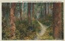
| Date: | 1913 |
|---|---|
| Description: | Colorized postcard of a hiking trail winding through the forest. Some trees are showing autumn color. Caption reads: "Brule River State Park, Wisconsin. Al... |
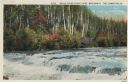
| Date: | 1913 |
|---|---|
| Description: | Colorized postcard view of the Lower Falls on the Brule River flowing through the forest. Some trees are showing autumn color. Caption reads: "Brule River ... |
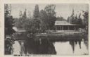
| Date: | |
|---|---|
| Description: | Black and white postcard view of the President's Dining Lodge on the Brule River surrounded by trees. A bridge is on the left. Caption reads: "President's ... |
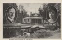
| Date: | 1926 |
|---|---|
| Description: | Black and white postcard view of Cedar Island Lodge, located on the Brule River, owned by Henry Clay Pierce, businessman and financier. It was dubbed the S... |
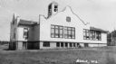
| Date: | 1937 |
|---|---|
| Description: | Large white building with facade details and bell tower. |

| Date: | |
|---|---|
| Description: | Letterhead of the City of Superior, Wisconsin, with a three-quarter view of City Hall, printed in blue-green ink, with additional text in brown ink, by Typ... |
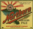
| Date: | |
|---|---|
| Description: | Label for Northern Pale brewed by Northern Brewing Company. The label depicts a lake scene with evergreen trees in the background and the round Northern Be... |
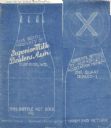
| Date: | 02 14 1935 |
|---|---|
| Description: | Blueprint submitted to the State of Wisconsin for trademark registration from the Superior Milk Dealers Association. Features a drawing of the bottle and b... |
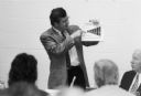
| Date: | 06 1992 |
|---|---|
| Description: | During the 1990s Congressman David R. Obey, a leading proponent of health care reform, held numerous forums on the subject in his northern Wisconsin distri... |
| Date: | 09 07 1895 |
|---|---|
| Description: | A garden of red currant bushes, owned by Jas. S. Ritchie, are featured on his fruit farm. |
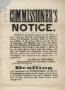
| Date: | 08 28 1862 |
|---|---|
| Description: | A Commissioner's Notice of the draft, beginning on the first of September. On the first two days, claims of exemption from military service were to be hear... |
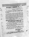
| Date: | 08 31 1862 |
|---|---|
| Description: | Photograph of a printed broadside, Public Order No. 1., issued by The Committee of Safety. The first order appears to be addressing some kind of dangerous ... |
| Date: | 1932 |
|---|---|
| Description: | "Mexican Room" at the Bellwood. The room has many chairs, tables and lamps, and a brick fireplace is on the left. Three plants in a holder stand in front o... |

| Date: | 1891 |
|---|---|
| Description: | Photograph of a painting by May Conniff Frost showing the tugboat Record of the Inman Line pulling a lake schooner through rough waters into Superio... |

| Date: | 1889 |
|---|---|
| Description: | This 1889 map of Douglas County, Wisconsin, shows the township and range grid, towns, sections, cities and villages, roads, existing and proposed railroads... |

| Date: | 1892 |
|---|---|
| Description: | This 1892 map of Douglas County, Wisconsin, shows the township and range grid, towns, sections, cities and villages, roads, railroads, trails, lakes and st... |

| Date: | 1899 |
|---|---|
| Description: | This 1899 map of Douglas County, Wisconsin, shows the township and range grid, towns, sections, cities, villages and railroad stations, mines, roads, railr... |

| Date: | 1911 |
|---|---|
| Description: | This map, taken from the 1911 Map of Wisconsin showing geology and roads by Hotchkiss and Thwaites, shows the northwest portion of Douglas County, Wisconsi... |

| Date: | 1914 |
|---|---|
| Description: | This 1914 map of Douglas County, Wisconsin, shows the township and range grid, towns, sections, cities and villages, roads, railroads, Indian trails, schoo... |

| Date: | 1919 |
|---|---|
| Description: | "Map showing the main travelled State and Federal Highways upon which the County Board proposes to expend $1,200,000 for permanent improvements, if you wil... |
If you didn't find the material you searched for, our Library Reference Staff can help.
Call our reference desk at 608-264-6535 or email us at: