Filter: Categories of Wisconsin Historical Images
Filter: County of Calumet
Filter: Community of Stockbridge
Filter: Categories of Wisconsin Historical Images
Filter: County of Calumet
Filter: Community of Stockbridge
| Date: | 1910 |
|---|---|
| Description: | Exterior view of the Stockbridge Indian Mission, built in about 1834, with several figures and a horse standing in the structure's doorway. |
| Date: | 1913 |
|---|---|
| Description: | Exterior view of the Stockbridge Indian Mission with men standing near its entrance. |
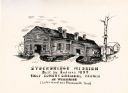
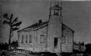
| Date: | 1835 |
|---|---|
| Description: | Drawing of the Stockbridge Indian Mission, built in about 1834. |
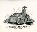
| Date: | 1835 |
|---|---|
| Description: | Drawing of the Stockbridge Indian mission. |
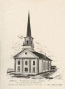
| Date: | 1899 |
|---|---|
| Description: | Exterior view of the First Congregational Church. |
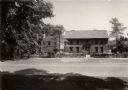
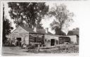
| Date: | 1933 |
|---|---|
| Description: | Exterior view of a Mission House built in about 1740. |
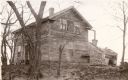
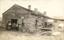
| Date: | |
|---|---|
| Description: | View of the dwelling of Cutting Marsh, missionary to the Stockbridge Indians. |

| Date: | |
|---|---|
| Description: | Hand-colored carte-de-visite portrait of Edith Acker with hat and parasol. She married Rossiter Grignon. |
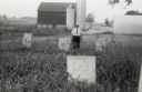
| Date: | 1958 |
|---|---|
| Description: | Local historian William F. Wolf visiting the Native American cemetery. In the background is a barn and a silo and other farm buildings. |

| Date: | |
|---|---|
| Description: | Carte-de-visite portrait of Miriam Scott of Stockbridge, Wisconsin, a sister of E.W. Scott. |
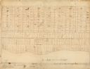
| Date: | |
|---|---|
| Description: | This map, which was likely drawn in the mid-19th century, shows land ownership on the Stockbridge Reservation on the shore of Lake Winnebago in what is now... |
| Date: | 1943 |
|---|---|
| Description: | Map shows the town of St. Catherine, Wisconsin, between Lake Street and Doty Street as it appeared on January 3, 1852. Map is situated facing north with La... |

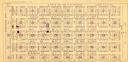
| Date: | 1900 |
|---|---|
| Description: | This map shows landownership circa 1848 in the old Stockbridge Indian reservation on Lake Winnebago in Calumet County. It is oriented with north to the lef... |
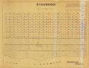
| Date: | 1955 |
|---|---|
| Description: | This map shows landownership in the old Stockbridge Indian reservation on Lake Winnebago in Calumet County. The lots are numbered and labeled by owner. A b... |

| Date: | 1910 |
|---|---|
| Description: | An unidentified man standing in a wooded area. A light snowfall has highlighted linear ridges in the soil which indicate the location of Stockbridge Indian... |
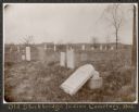
| Date: | 1906 |
|---|---|
| Description: | View of a cemetery with several tombstones, one of which appears broken and resting against its base. A building is in the background. Caption reads: "Th... |
If you didn't find the material you searched for, our Library Reference Staff can help.
Call our reference desk at 608-264-6535 or email us at: