 Filter: Categories of Wisconsin Historical Images
Filter: County of Calumet
Filter: Community of Brothertown
Filter: Categories of Wisconsin Historical Images
Filter: County of Calumet
Filter: Community of Brothertown
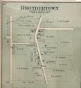
| Date: | 1893 |
|---|---|
| Description: | Plat map of Brothertown in Calumet County. |

| Date: | |
|---|---|
| Description: | Exterior view of the school at Brothertown. with students and teacher posed outdoors around the front steps. |

| Date: | |
|---|---|
| Description: | Group of students and a teacher posed outside a school building. One boy holds a chalkboard sign reading "Brothertown Dist. No. 2." |

| Date: | 1974 |
|---|---|
| Description: | This map draws content from a map originally created by George Featherstongaugh in 1840. The map shows streets, land ownership, the Brotherton Indian reser... |
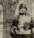
| Date: | 03 1934 |
|---|---|
| Description: | View of a woman holding a large bound volume and standing next to a tree. Caption reads: "An Indian woman of over 70 [Lura Fowler Kindness] who lives by he... |
If you didn't find the material you searched for, our Library Reference Staff can help.
Call our reference desk at 608-264-6535 or email us at: