 Filter: Categories of Wisconsin Historical Images
Filter: County of Barron
Filter: Type of Map or Atlas
Filter: Categories of Wisconsin Historical Images
Filter: County of Barron
Filter: Type of Map or Atlas
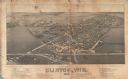
| Date: | 1884 |
|---|---|
| Description: | Like many early settlements of southeastern Wisconsin, Clinton was founded in 1836 by Yankees--immigrants from New England and New York. |

| Date: | 1912 |
|---|---|
| Description: | This early 20th century map of Barron County, Wisconsin, shows the township and range grid, towns, sections, cities and villages, railroads, roads, houses,... |

| Date: | 1939 |
|---|---|
| Description: | This 1939 map of Barron County, Wisconsin, shows the township and range grid, sections, cities and villages, and lakes and streams in the county. It lacks ... |
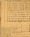
| Date: | 1929 |
|---|---|
| Description: | This 1929 survey of Meadow Creek Cemetery in the Town of Stanley, Barron County, Wisconsin, shows cemetery plots bordered by U.S. Route 53 (now County SS) ... |

| Date: | 1882 |
|---|---|
| Description: | This 1882 map of Barron County, Wisconsin, shows the township and range grid, towns, cities and villages, wagon roads, railroads, schools, dwellings, and l... |

| Date: | 1901 |
|---|---|
| Description: | This 1901 map of Barron County, Wisconsin, shows the township and range grid, towns, cities and villages, roads, railroads, and lakes and streams. |
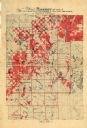
| Date: | 1917 |
|---|---|
| Description: | Map of Barron and parts of Dunn, Chippewa, Washburn & Sawyer counties, State of Wisconsin, showing the lands of the Knapp, Stout & Co. Company, of Menomoni... |

| Date: | 1969 |
|---|---|
| Description: | This map shows businesses, resorts, roads, public boat landings, schools, cemeteries, and location of fish and game. An inset map reads: Continuation along... |

| Date: | 1960 |
|---|---|
| Description: | This map shows improved town roads, federal highways, county highways, public boat access, public hunting areas, railroads, and lakes in the area around th... |
If you didn't find the material you searched for, our Library Reference Staff can help.
Call our reference desk at 608-264-6535 or email us at: